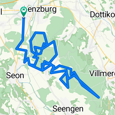
20141209_105328.gpx
A cycling route starting in Staufen, Canton of Aargau, Switzerland.
Overview
About this route
.TEASI track
Lockere Route von Staufen-Esterlitum-Egliswil-Tanzbode-Seengen-Retterswil-zurück nach Staufen. ca. 800 Höhenmeter- -:--
- Duration
- 33.5 km
- Distance
- 527 m
- Ascent
- 527 m
- Descent
- ---
- Avg. speed
- ---
- Max. altitude
Route quality
Waytypes & surfaces along the route
Waytypes
Track
19.1 km
(57 %)
Quiet road
9 km
(27 %)
Surfaces
Paved
5 km
(15 %)
Unpaved
15.1 km
(45 %)
Gravel
14.4 km
(43 %)
Asphalt
4.4 km
(13 %)
Continue with Bikemap
Use, edit, or download this cycling route
You would like to ride 20141209_105328.gpx or customize it for your own trip? Here is what you can do with this Bikemap route:
Free features
- Save this route as favorite or in collections
- Copy & plan your own version of this route
- Sync your route with Garmin or Wahoo
Premium features
Free trial for 3 days, or one-time payment. More about Bikemap Premium.
- Navigate this route on iOS & Android
- Export a GPX / KML file of this route
- Create your custom printout (try it for free)
- Download this route for offline navigation
Discover more Premium features.
Get Bikemap PremiumFrom our community
Other popular routes starting in Staufen
- Villmergen-Seengen
- Distance
- 32.2 km
- Ascent
- 377 m
- Descent
- 378 m
- Location
- Staufen, Canton of Aargau, Switzerland
- 20160929_101158.gpx
- Distance
- 37.8 km
- Ascent
- 484 m
- Descent
- 485 m
- Location
- Staufen, Canton of Aargau, Switzerland
- Hallwilersee Rundfahrt
- Distance
- 43 km
- Ascent
- 436 m
- Descent
- 435 m
- Location
- Staufen, Canton of Aargau, Switzerland
- Anglikon - Rl
- Distance
- 33.2 km
- Ascent
- 278 m
- Descent
- 280 m
- Location
- Staufen, Canton of Aargau, Switzerland
- Langsame Fahrt in Lenzburg
- Distance
- 4.4 km
- Ascent
- 149 m
- Descent
- 152 m
- Location
- Staufen, Canton of Aargau, Switzerland
- 20151110_105311.gpx
- Distance
- 50.7 km
- Ascent
- 678 m
- Descent
- 679 m
- Location
- Staufen, Canton of Aargau, Switzerland
- Villmergen Meisterschwanden- Seon
- Distance
- 35.3 km
- Ascent
- 387 m
- Descent
- 386 m
- Location
- Staufen, Canton of Aargau, Switzerland
- 20141209_105328.gpx
- Distance
- 33.5 km
- Ascent
- 527 m
- Descent
- 527 m
- Location
- Staufen, Canton of Aargau, Switzerland
Open it in the app