

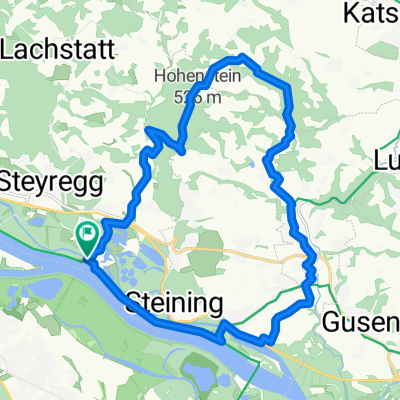
Südlicher Pfenningberg
A cycling route starting in Steyregg, Upper Austria, Austria.
Overview
About this route
Den Pfenningberg mal von Süden zu befahren ist nicht nur abwechslungsreich, sondern auch landschaftlich besonders reizvoll.
Besonders geeignet ist die Strecke zum Traininieren seiner Fähigkeiten auf dem Mountainbike - der Anstieg ist nicht steil, aber regelmäßig ansteigend, gerade so viel, daß auch ungeübte die meiste Zeit auf dem Rad sitzen bleiben können. Reizvoll ist die Strecke aber auch für "alte Hasen", denn auf einigen wenigen Abschnitten ist der Anstieg richtig steil.
Insgesamt eine der besten Routen in der Umgebung!
- -:--
- Duration
- 8.9 km
- Distance
- 416 m
- Ascent
- 300 m
- Descent
- ---
- Avg. speed
- ---
- Max. altitude
Continue with Bikemap
Use, edit, or download this cycling route
You would like to ride Südlicher Pfenningberg or customize it for your own trip? Here is what you can do with this Bikemap route:
Free features
- Save this route as favorite or in collections
- Copy & plan your own version of this route
- Sync your route with Garmin or Wahoo
Premium features
Free trial for 3 days, or one-time payment. More about Bikemap Premium.
- Navigate this route on iOS & Android
- Export a GPX / KML file of this route
- Create your custom printout (try it for free)
- Download this route for offline navigation
Discover more Premium features.
Get Bikemap PremiumFrom our community
Other popular routes starting in Steyregg
 Mountainbike SolarCity - GIS (Giselawarte)
- Distance
- 27.3 km
- Ascent
- 778 m
- Descent
- 101 m
- Location
- Steyregg, Upper Austria, Austria
 erste Etappe Ly und jo
- Distance
- 75.9 km
- Ascent
- 386 m
- Descent
- 136 m
- Location
- Steyregg, Upper Austria, Austria
 MTB Runde 55km - Satzing - Pürach - Götzelsdorf - Holzwinden - Lachstadt - Pfenningberg - Plesching - Linz-Urfahr - Lichtenberg - GIS Warte - Lichtenberg - Linz
- Distance
- 55.7 km
- Ascent
- 1,295 m
- Descent
- 1,297 m
- Location
- Steyregg, Upper Austria, Austria
 Hohenstein
- Distance
- 21.5 km
- Ascent
- 306 m
- Descent
- 308 m
- Location
- Steyregg, Upper Austria, Austria
 MTB Runde 45km - Statzing
- Distance
- 45.3 km
- Ascent
- 952 m
- Descent
- 952 m
- Location
- Steyregg, Upper Austria, Austria
 Nette Abendrunde
- Distance
- 39.2 km
- Ascent
- 472 m
- Descent
- 465 m
- Location
- Steyregg, Upper Austria, Austria
 MTB Runde 20km - Pürach - Götzelsdorf - Haid - Wolfing - Hohenstein - Weingraben - St. Georgen
- Distance
- 20.5 km
- Ascent
- 353 m
- Descent
- 353 m
- Location
- Steyregg, Upper Austria, Austria
 Linz-Königswiesen-Grein-Linz
- Distance
- 151.6 km
- Ascent
- 935 m
- Descent
- 923 m
- Location
- Steyregg, Upper Austria, Austria
Open it in the app