

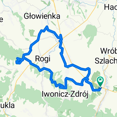
Bieg tarnina + kalwaria
A cycling route starting in Rymanów, Subcarpathian Voivodeship, Poland.
Overview
About this route
grudzień 2014
- -:--
- Duration
- 4.4 km
- Distance
- 151 m
- Ascent
- 153 m
- Descent
- ---
- Avg. speed
- ---
- Max. altitude
Continue with Bikemap
Use, edit, or download this cycling route
You would like to ride Bieg tarnina + kalwaria or customize it for your own trip? Here is what you can do with this Bikemap route:
Free features
- Save this route as favorite or in collections
- Copy & plan your own version of this route
- Sync your route with Garmin or Wahoo
Premium features
Free trial for 3 days, or one-time payment. More about Bikemap Premium.
- Navigate this route on iOS & Android
- Export a GPX / KML file of this route
- Create your custom printout (try it for free)
- Download this route for offline navigation
Discover more Premium features.
Get Bikemap PremiumFrom our community
Other popular routes starting in Rymanów
 Rymanów - Pustki - Klimkówa - wiatraki - Iwonicz - Miejsce Piastowe - Wrocanka - Niżna Łąka - Równe - Wietrzno - Równe - Rogi - Iwonicz - Klimkówka - Pustki - R
- Distance
- 43 km
- Ascent
- 539 m
- Descent
- 539 m
- Location
- Rymanów, Subcarpathian Voivodeship, Poland
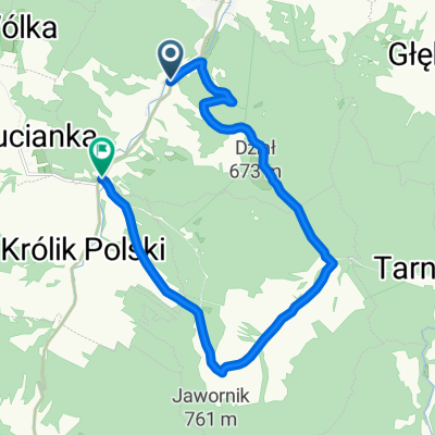 taki fajny łącznikdo trasy z Cergową
- Distance
- 13.6 km
- Ascent
- 464 m
- Descent
- 433 m
- Location
- Rymanów, Subcarpathian Voivodeship, Poland
 Rymanów - Trześmiów - Długie
- Distance
- 25.3 km
- Ascent
- 101 m
- Descent
- 134 m
- Location
- Rymanów, Subcarpathian Voivodeship, Poland
 zródła jasiołki, polany surowiczne, przymiarki
- Distance
- 83.5 km
- Ascent
- 1,459 m
- Descent
- 1,450 m
- Location
- Rymanów, Subcarpathian Voivodeship, Poland
 20220902
- Distance
- 88 km
- Ascent
- 833 m
- Descent
- 833 m
- Location
- Rymanów, Subcarpathian Voivodeship, Poland
 Zdrojowa 57, Rymanów-Zdrój do Zdrojowa 57, Rymanów-Zdrój
- Distance
- 51 km
- Ascent
- 774 m
- Descent
- 774 m
- Location
- Rymanów, Subcarpathian Voivodeship, Poland
 Rymanów-kalwaria-mogiła-sucha góra-klimkówka-łysa góra-pustki-rymanów
- Distance
- 18.5 km
- Ascent
- 583 m
- Descent
- 581 m
- Location
- Rymanów, Subcarpathian Voivodeship, Poland
 3/2018
- Distance
- 46.9 km
- Ascent
- 840 m
- Descent
- 862 m
- Location
- Rymanów, Subcarpathian Voivodeship, Poland
Open it in the app