

Schwäbisch Gmünd Seenlandschaft im Welzheimer Wald
A cycling route starting in Mutlangen, Baden-Württemberg, Germany.
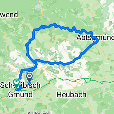
Overview
About this route
Schwäbisch Gmünd - Täferrot - Pfahlbronn - Lorch - Schwäbisch Gmünd vorbei an etlichen Stausseen.
Aus der Broschüre "die 13 schönsten Fahrradtouren rund um Schwäbisch Gmünd"- -:--
- Duration
- 59.5 km
- Distance
- 514 m
- Ascent
- 517 m
- Descent
- ---
- Avg. speed
- ---
- Max. altitude

Route quality
Waytypes & surfaces along the route
Waytypes
Track
30.7 km
(52 %)
Quiet road
16.8 km
(28 %)
Surfaces
Paved
38.4 km
(64 %)
Unpaved
17.4 km
(29 %)
Asphalt
26.7 km
(45 %)
Gravel
15.2 km
(26 %)
Continue with Bikemap
Use, edit, or download this cycling route
You would like to ride Schwäbisch Gmünd Seenlandschaft im Welzheimer Wald or customize it for your own trip? Here is what you can do with this Bikemap route:
Free features
- Save this route as favorite or in collections
- Copy & plan your own version of this route
- Sync your route with Garmin or Wahoo
Premium features
Free trial for 3 days, or one-time payment. More about Bikemap Premium.
- Navigate this route on iOS & Android
- Export a GPX / KML file of this route
- Create your custom printout (try it for free)
- Download this route for offline navigation
Discover more Premium features.
Get Bikemap PremiumFrom our community
Other popular routes starting in Mutlangen
 Schwäbisch Gmünd Seenlandschaft im Welzheimer Wald
- Distance
- 59.5 km
- Ascent
- 514 m
- Descent
- 517 m
- Location
- Mutlangen, Baden-Württemberg, Germany
 Spraitbach - Durlangen
- Distance
- 31.5 km
- Ascent
- 269 m
- Descent
- 270 m
- Location
- Mutlangen, Baden-Württemberg, Germany
 Mutlangen - Ebnisee
- Distance
- 60.4 km
- Ascent
- 757 m
- Descent
- 723 m
- Location
- Mutlangen, Baden-Württemberg, Germany
 Wetzgau 7km
- Distance
- 6.8 km
- Ascent
- 150 m
- Descent
- 155 m
- Location
- Mutlangen, Baden-Württemberg, Germany
 Rehnenmühle
- Distance
- 17.1 km
- Ascent
- 173 m
- Descent
- 174 m
- Location
- Mutlangen, Baden-Württemberg, Germany
 Schwäbisch Gmünd - Lorch - Limes - Lindach - Schwäbisch Gmünd
- Distance
- 35.5 km
- Ascent
- 280 m
- Descent
- 263 m
- Location
- Mutlangen, Baden-Württemberg, Germany
 Radrunde Kloster.schelmenklinge. Alfdorf
- Distance
- 15.8 km
- Ascent
- 271 m
- Descent
- 306 m
- Location
- Mutlangen, Baden-Württemberg, Germany
 leital kochertal
- Distance
- 58.3 km
- Ascent
- 697 m
- Descent
- 638 m
- Location
- Mutlangen, Baden-Württemberg, Germany
Open it in the app