
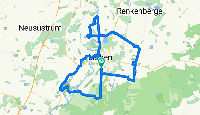
Rund um Lathen
A cycling route starting in Lathen, Lower Saxony, Germany.
Overview
About this route
from Lathen-Frakel (sports field) - Magnet Schwebebahn - Memorial site - Altwahn - Melstrup - Fresenburg (country house 'Unter den Eichen') - Düther lock - Fresenburg - Lathen - Niederlangen - Oberlangen - Beel - Hilter lock - Hilter - Hilterberg - Frakel
- -:--
- Duration
- 37.8 km
- Distance
- 48 m
- Ascent
- 48 m
- Descent
- ---
- Avg. speed
- ---
- Max. altitude
Route quality
Waytypes & surfaces along the route
Waytypes
Quiet road
20.8 km
(55 %)
Path
5.7 km
(15 %)
Surfaces
Paved
25.7 km
(68 %)
Unpaved
0.8 km
(2 %)
Asphalt
25.7 km
(68 %)
Loose gravel
0.8 km
(2 %)
Undefined
11.3 km
(30 %)
Continue with Bikemap
Use, edit, or download this cycling route
You would like to ride Rund um Lathen or customize it for your own trip? Here is what you can do with this Bikemap route:
Free features
- Save this route as favorite or in collections
- Copy & plan your own version of this route
- Sync your route with Garmin or Wahoo
Premium features
Free trial for 3 days, or one-time payment. More about Bikemap Premium.
- Navigate this route on iOS & Android
- Export a GPX / KML file of this route
- Create your custom printout (try it for free)
- Download this route for offline navigation
Discover more Premium features.
Get Bikemap PremiumFrom our community
Other popular routes starting in Lathen
 Radtour 2018 3.Etappe
- Distance
- 130.2 km
- Ascent
- 130 m
- Descent
- 77 m
- Location
- Lathen, Lower Saxony, Germany
 Rund um Lathen Route 2
- Distance
- 37.4 km
- Ascent
- 64 m
- Descent
- 63 m
- Location
- Lathen, Lower Saxony, Germany
 Ems-Radweg E2 (Lathen -> Rheine)
- Distance
- 108.1 km
- Ascent
- 106 m
- Descent
- 76 m
- Location
- Lathen, Lower Saxony, Germany
 Rund um Lathen
- Distance
- 37.8 km
- Ascent
- 48 m
- Descent
- 48 m
- Location
- Lathen, Lower Saxony, Germany
 lathen
- Distance
- 35.3 km
- Ascent
- 87 m
- Descent
- 88 m
- Location
- Lathen, Lower Saxony, Germany
 Marschstraße, Lathen nach Marschstraße, Lathen
- Distance
- 29.9 km
- Ascent
- 676 m
- Descent
- 676 m
- Location
- Lathen, Lower Saxony, Germany
 Lathen_4_-_Kloster_Ter_Aepel
- Distance
- 58 km
- Ascent
- 62 m
- Descent
- 61 m
- Location
- Lathen, Lower Saxony, Germany
 N-NL dag 9 Denekamp 90km
- Distance
- 89.5 km
- Ascent
- 76 m
- Descent
- 62 m
- Location
- Lathen, Lower Saxony, Germany
Open it in the app