

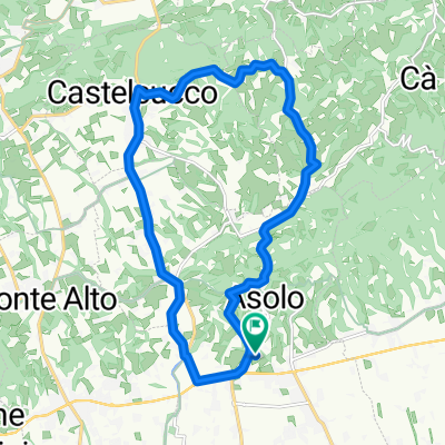
grappa + pianezze
A cycling route starting in Asolo, Veneto, Italy.
Overview
About this route
two long climbs plus a grip of Montello
- -:--
- Duration
- 122.9 km
- Distance
- 2,431 m
- Ascent
- 2,435 m
- Descent
- ---
- Avg. speed
- ---
- Max. altitude
Continue with Bikemap
Use, edit, or download this cycling route
You would like to ride grappa + pianezze or customize it for your own trip? Here is what you can do with this Bikemap route:
Free features
- Save this route as favorite or in collections
- Copy & plan your own version of this route
- Split it into stages to create a multi-day tour
- Sync your route with Garmin or Wahoo
Premium features
Free trial for 3 days, or one-time payment. More about Bikemap Premium.
- Navigate this route on iOS & Android
- Export a GPX / KML file of this route
- Create your custom printout (try it for free)
- Download this route for offline navigation
Discover more Premium features.
Get Bikemap PremiumFrom our community
Other popular routes starting in Asolo
 ride through Asolo
- Distance
- 23.1 km
- Ascent
- 354 m
- Descent
- 354 m
- Location
- Asolo, Veneto, Italy
 Asolo-Asolo
- Distance
- 34.4 km
- Ascent
- 469 m
- Descent
- 473 m
- Location
- Asolo, Veneto, Italy
 Tappa 14 del Giro d'Italia - Cover dell'Anonima Ciclista
- Distance
- 42.8 km
- Ascent
- 1,883 m
- Descent
- 248 m
- Location
- Asolo, Veneto, Italy
 ONIGO
ONIGO- Distance
- 46.1 km
- Ascent
- 556 m
- Descent
- 557 m
- Location
- Asolo, Veneto, Italy
 Da Via Santa Colomba a Via Santa Colomba
- Distance
- 17.3 km
- Ascent
- 257 m
- Descent
- 310 m
- Location
- Asolo, Veneto, Italy
 Via Roma 72, Asolo nach Via Tessere 1, Valdobbiadene
- Distance
- 19.4 km
- Ascent
- 186 m
- Descent
- 214 m
- Location
- Asolo, Veneto, Italy
 Giro MTB per Asolo
- Distance
- 46.9 km
- Ascent
- 552 m
- Descent
- 552 m
- Location
- Asolo, Veneto, Italy
 Rundkurs Asolo-Castelcucco
- Distance
- 22.9 km
- Ascent
- 316 m
- Descent
- 323 m
- Location
- Asolo, Veneto, Italy
Open it in the app