

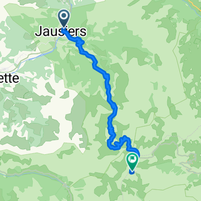
Francia Alpok 06 kör
A cycling route starting in Jausiers, Provence-Alpes-Côte d'Azur Region, France.
Overview
About this route
Cime de la Bonette (2802 m) Col de la Moutière (2454 m)
- -:--
- Duration
- 98.8 km
- Distance
- 2,659 m
- Ascent
- 2,659 m
- Descent
- ---
- Avg. speed
- ---
- Max. altitude

Route highlights
Points of interest along the route
Point of interest after 21.7 km
Cime de la Bonette (2802 m)
Point of interest after 57.5 km
Col de la Moutière (2454 m)
Continue with Bikemap
Use, edit, or download this cycling route
You would like to ride Francia Alpok 06 kör or customize it for your own trip? Here is what you can do with this Bikemap route:
Free features
- Save this route as favorite or in collections
- Copy & plan your own version of this route
- Split it into stages to create a multi-day tour
- Sync your route with Garmin or Wahoo
Premium features
Free trial for 3 days, or one-time payment. More about Bikemap Premium.
- Navigate this route on iOS & Android
- Export a GPX / KML file of this route
- Create your custom printout (try it for free)
- Download this route for offline navigation
Discover more Premium features.
Get Bikemap PremiumFrom our community
Other popular routes starting in Jausiers
 okolo Lac de Serre-Poncon + Bonette
- Distance
- 180.9 km
- Ascent
- 2,172 m
- Descent
- 2,172 m
- Location
- Jausiers, Provence-Alpes-Côte d'Azur Region, France
 Jausieres - Col de la Bonette
- Distance
- 23.7 km
- Ascent
- 1,599 m
- Descent
- 27 m
- Location
- Jausiers, Provence-Alpes-Côte d'Azur Region, France
 Francia Alpok 06 kör
- Distance
- 98.8 km
- Ascent
- 2,659 m
- Descent
- 2,659 m
- Location
- Jausiers, Provence-Alpes-Côte d'Azur Region, France
 Col de Vars Roundtrip/Okruh kolem Col de Vars
- Distance
- 124.5 km
- Ascent
- 1,663 m
- Descent
- 1,663 m
- Location
- Jausiers, Provence-Alpes-Côte d'Azur Region, France
 Col de la cime della Bonette m.2802 - Jausieres
- Distance
- 23.6 km
- Ascent
- 10 m
- Descent
- 1,576 m
- Location
- Jausiers, Provence-Alpes-Côte d'Azur Region, France
 8. Etappe Oberdiessbach Le Lavandou Teil 2
- Distance
- 11.4 km
- Ascent
- 775 m
- Descent
- 650 m
- Location
- Jausiers, Provence-Alpes-Côte d'Azur Region, France
 Dag 5a. Jausiers-Castellane. Camping calme et Nature
- Distance
- 33.5 km
- Ascent
- 1,101 m
- Descent
- 473 m
- Location
- Jausiers, Provence-Alpes-Côte d'Azur Region, France
 Tunnel du Parpaillon
- Distance
- 49.4 km
- Ascent
- 1,508 m
- Descent
- 1,811 m
- Location
- Jausiers, Provence-Alpes-Côte d'Azur Region, France
Open it in the app