

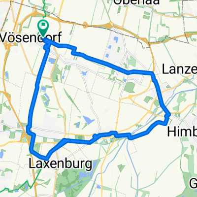
Alterlaa - Kahlenberg - Alterlaa
A cycling route starting in Vösendorf, Lower Austria, Austria.
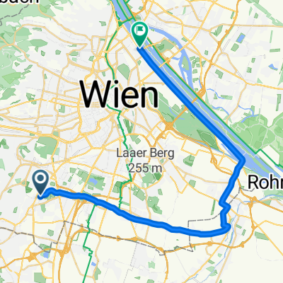
Overview
About this route
Alterlaa U6 - 14th District - Dehnepark - Jubiläumswarte (due to the poor resolution of the aerial images, it's hard to mark the right path) - Kreuzeichenwiese - Schwarzenbergpark - Neustift am Walde - Häusler am Stoan - Sievering - Gspöttpgraben - Am Himmel - Cobenzl - Kahlenberg - Kahlenbergerstr. - Danube Canal Cycle Path to WU - Gürtel Cycle Path to Westbahnhof - Felberstr - Auer-Welsbach-Park - 12th District - Oswaldgasse Cycle Path - Schöpfwerk - Bicycle-Highway Bridge - Liesingbach Cycle Path - Alterlaa U6
- -:--
- Duration
- 47.2 km
- Distance
- 705 m
- Ascent
- 708 m
- Descent
- ---
- Avg. speed
- ---
- Max. altitude

Continue with Bikemap
Use, edit, or download this cycling route
You would like to ride Alterlaa - Kahlenberg - Alterlaa or customize it for your own trip? Here is what you can do with this Bikemap route:
Free features
- Save this route as favorite or in collections
- Copy & plan your own version of this route
- Sync your route with Garmin or Wahoo
Premium features
Free trial for 3 days, or one-time payment. More about Bikemap Premium.
- Navigate this route on iOS & Android
- Export a GPX / KML file of this route
- Create your custom printout (try it for free)
- Download this route for offline navigation
Discover more Premium features.
Get Bikemap PremiumFrom our community
Other popular routes starting in Vösendorf
 Weg der Ziegelbarone
- Distance
- 23.8 km
- Ascent
- 36 m
- Descent
- 37 m
- Location
- Vösendorf, Lower Austria, Austria
 2026 Burgenland: 1: Wien-Pitten
- Distance
- 65.3 km
- Ascent
- 198 m
- Descent
- 70 m
- Location
- Vösendorf, Lower Austria, Austria
 Schöpfwerk - Wiener Hütte
- Distance
- 25.4 km
- Ascent
- 227 m
- Descent
- 227 m
- Location
- Vösendorf, Lower Austria, Austria
 Roter Ofen Umweg
- Distance
- 46.2 km
- Ascent
- 403 m
- Descent
- 402 m
- Location
- Vösendorf, Lower Austria, Austria
 Hernstein 1100/47 Gravel Anninger Vöslauer Hütte
- Distance
- 46.9 km
- Ascent
- 1,136 m
- Descent
- 907 m
- Location
- Vösendorf, Lower Austria, Austria
 Hetzendorfer Straße - Eglseegasse
- Distance
- 53.6 km
- Ascent
- 385 m
- Descent
- 435 m
- Location
- Vösendorf, Lower Austria, Austria
 Dr-Pertich-Gasse, Vösendorf nach Dr-Pertich-Gasse, Vösendorf
- Distance
- 52.1 km
- Ascent
- 436 m
- Descent
- 431 m
- Location
- Vösendorf, Lower Austria, Austria
 Route in Wien
- Distance
- 28.5 km
- Ascent
- 33 m
- Descent
- 70 m
- Location
- Vösendorf, Lower Austria, Austria
Open it in the app