

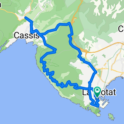
notre dame de mai à l'envers
A cycling route starting in La Ciotat, Provence-Alpes-Côte d'Azur Region, France.
Overview
About this route
notre dame de mai upside down
- -:--
- Duration
- 71.2 km
- Distance
- 660 m
- Ascent
- 660 m
- Descent
- ---
- Avg. speed
- ---
- Max. altitude

Route quality
Waytypes & surfaces along the route
Waytypes
Road
13.5 km
(19 %)
Cycleway
3.6 km
(5 %)
Surfaces
Paved
49.8 km
(70 %)
Asphalt
49.8 km
(70 %)
Undefined
21.4 km
(30 %)
Continue with Bikemap
Use, edit, or download this cycling route
You would like to ride notre dame de mai à l'envers or customize it for your own trip? Here is what you can do with this Bikemap route:
Free features
- Save this route as favorite or in collections
- Copy & plan your own version of this route
- Sync your route with Garmin or Wahoo
Premium features
Free trial for 3 days, or one-time payment. More about Bikemap Premium.
- Navigate this route on iOS & Android
- Export a GPX / KML file of this route
- Create your custom printout (try it for free)
- Download this route for offline navigation
Discover more Premium features.
Get Bikemap PremiumFrom our community
Other popular routes starting in La Ciotat
 70 -Départ par Belle-Fille, Cassis, La Bédoule, vallon d Aubagne, Col de l Ange, Le Camp, tour circuit, Le Beausset
- Distance
- 77.1 km
- Ascent
- 1,205 m
- Descent
- 1,124 m
- Location
- La Ciotat, Provence-Alpes-Côte d'Azur Region, France
 notre dame de mai à l'envers
- Distance
- 71.2 km
- Ascent
- 660 m
- Descent
- 660 m
- Location
- La Ciotat, Provence-Alpes-Côte d'Azur Region, France
 port d'alons
- Distance
- 47.4 km
- Ascent
- 497 m
- Descent
- 496 m
- Location
- La Ciotat, Provence-Alpes-Côte d'Azur Region, France
 La Ciotat Roquefort cassis and back
- Distance
- 32 km
- Ascent
- 531 m
- Descent
- 529 m
- Location
- La Ciotat, Provence-Alpes-Côte d'Azur Region, France
 La Ciotat kleine Runde
- Distance
- 15.2 km
- Ascent
- 450 m
- Descent
- 427 m
- Location
- La Ciotat, Provence-Alpes-Côte d'Azur Region, France
 la ciotat -casis route crete
- Distance
- 29.8 km
- Ascent
- 672 m
- Descent
- 672 m
- Location
- La Ciotat, Provence-Alpes-Côte d'Azur Region, France
 01- Départ par St Cyr - Bandol - les gorges de Ollioules, Le Beausset, Le Brulat,St Cyr
- Distance
- 61.9 km
- Ascent
- 797 m
- Descent
- 758 m
- Location
- La Ciotat, Provence-Alpes-Côte d'Azur Region, France
 Medium length evening ride
- Distance
- 42.4 km
- Ascent
- 901 m
- Descent
- 901 m
- Location
- La Ciotat, Provence-Alpes-Côte d'Azur Region, France
Open it in the app