

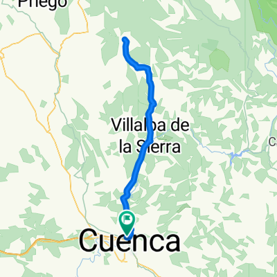
Senda de los quads, trialera Valdecabras, Rambla Miralles
A cycling route starting in Cuenca, Castille-La Mancha, Spain.
Overview
About this route
Quad trail, Valdecabras trail, Buenache de la Sierra, Rambla Miralles Botanical Path, Cuenca
- -:--
- Duration
- 57.8 km
- Distance
- 968 m
- Ascent
- 969 m
- Descent
- ---
- Avg. speed
- ---
- Max. altitude
Route quality
Waytypes & surfaces along the route
Waytypes
Track
18.5 km
(32 %)
Path
17.3 km
(30 %)
Surfaces
Paved
5.8 km
(10 %)
Unpaved
20.2 km
(35 %)
Ground
9.8 km
(17 %)
Gravel
8.1 km
(14 %)
Route highlights
Points of interest along the route
Point of interest after 15.3 km
Senda de los quads
Point of interest after 31.2 km
¡ATENCION! Aquí nos tiramos por la línea de la luz. Con el paso del tiempo puede cambiar la senda.
Point of interest after 38 km
Rambla de Miralles
Point of interest after 46.8 km
Senda del Botanico
Continue with Bikemap
Use, edit, or download this cycling route
You would like to ride Senda de los quads, trialera Valdecabras, Rambla Miralles or customize it for your own trip? Here is what you can do with this Bikemap route:
Free features
- Save this route as favorite or in collections
- Copy & plan your own version of this route
- Sync your route with Garmin or Wahoo
Premium features
Free trial for 3 days, or one-time payment. More about Bikemap Premium.
- Navigate this route on iOS & Android
- Export a GPX / KML file of this route
- Create your custom printout (try it for free)
- Download this route for offline navigation
Discover more Premium features.
Get Bikemap PremiumFrom our community
Other popular routes starting in Cuenca
 Palomera, Buenache de la Sierra, Valdecabras.
- Distance
- 52.8 km
- Ascent
- 612 m
- Descent
- 613 m
- Location
- Cuenca, Castille-La Mancha, Spain
 Primer tramo Maraton "Sendas de Cuenca"
- Distance
- 37.7 km
- Ascent
- 668 m
- Descent
- 670 m
- Location
- Cuenca, Castille-La Mancha, Spain
 Cuenca - Cuevas Velasco - Valdecolmenas - Villarejo Peñuela - Cuenca
- Distance
- 80.7 km
- Ascent
- 879 m
- Descent
- 790 m
- Location
- Cuenca, Castille-La Mancha, Spain
 Cabeza Mosilla
- Distance
- 42.5 km
- Ascent
- 884 m
- Descent
- 884 m
- Location
- Cuenca, Castille-La Mancha, Spain
 2007 (Excursión Cuenca)
- Distance
- 105.9 km
- Ascent
- 914 m
- Descent
- 914 m
- Location
- Cuenca, Castille-La Mancha, Spain
 Cuenca - Villalba - Fresneda - Villalba - Cuenca
- Distance
- 85.1 km
- Ascent
- 813 m
- Descent
- 790 m
- Location
- Cuenca, Castille-La Mancha, Spain
 Carrera Montana de Jabaga en Bici
- Distance
- 51.9 km
- Ascent
- 811 m
- Descent
- 811 m
- Location
- Cuenca, Castille-La Mancha, Spain
 Vallejo del Pumar
- Distance
- 45.3 km
- Ascent
- 655 m
- Descent
- 654 m
- Location
- Cuenca, Castille-La Mancha, Spain
Open it in the app