

Towton
A cycling route starting in York, England, United Kingdom.
Overview
About this route
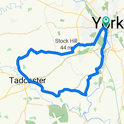
The route is R65 across Knavesmire, alongside A64 to Copmanthorpe/Askham Bryan roundabout, Askham Bryan,, Normans Farm, Catterton, Tadcaster, Roman Ridge, Bramham Crossroads via Route 67, round the north of the interchange on the cycle paths, Aberford, Lotherton Hall, Saxton (via Garlic Flats) and Towton for lunch at the Rockingham Arms. Return via Stutton, Tadcaster, Bolton Percy, Appleton Roebuck, Bishopthorpe, road/ cycle track to Terry's and retrace the outward route back to Morrisons
Route by Peter F- -:--
- Duration
- 63.8 km
- Distance
- 183 m
- Ascent
- 184 m
- Descent
- ---
- Avg. speed
- ---
- Max. altitude
Route quality
Waytypes & surfaces along the route
Waytypes
Road
29.3 km
(46 %)
Quiet road
15.3 km
(24 %)
Surfaces
Paved
43.4 km
(68 %)
Asphalt
42.7 km
(67 %)
Paved (undefined)
0.6 km
(1 %)
Undefined
20.4 km
(32 %)
Continue with Bikemap
Use, edit, or download this cycling route
You would like to ride Towton or customize it for your own trip? Here is what you can do with this Bikemap route:
Free features
- Save this route as favorite or in collections
- Copy & plan your own version of this route
- Sync your route with Garmin or Wahoo
Premium features
Free trial for 3 days, or one-time payment. More about Bikemap Premium.
- Navigate this route on iOS & Android
- Export a GPX / KML file of this route
- Create your custom printout (try it for free)
- Download this route for offline navigation
Discover more Premium features.
Get Bikemap PremiumFrom our community
Other popular routes starting in York
 Barton le willows
- Distance
- 49 km
- Ascent
- 141 m
- Descent
- 163 m
- Location
- York, England, United Kingdom
 The Southern Loop
- Distance
- 43.2 km
- Ascent
- 72 m
- Descent
- 72 m
- Location
- York, England, United Kingdom
 Ampleforth (Malton) 2018-05-30
- Distance
- 114.9 km
- Ascent
- 353 m
- Descent
- 360 m
- Location
- York, England, United Kingdom
 Fridaythorpe (Pockington) 2018-12-19
- Distance
- 84 km
- Ascent
- 395 m
- Descent
- 391 m
- Location
- York, England, United Kingdom
 York - Westow - York
- Distance
- 64.9 km
- Ascent
- 118 m
- Descent
- 114 m
- Location
- York, England, United Kingdom
 Tockwith Spotted Ox
- Distance
- 54.1 km
- Ascent
- 115 m
- Descent
- 110 m
- Location
- York, England, United Kingdom
 Tockwith
- Distance
- 54.4 km
- Ascent
- 1,529 m
- Descent
- 1,525 m
- Location
- York, England, United Kingdom
 37 Monkgate, York to 33 Huntington Road, York
- Distance
- 16.1 km
- Ascent
- 6 m
- Descent
- 13 m
- Location
- York, England, United Kingdom
Open it in the app