[run] 7,8 km przez G贸r臋 Ojca
A cycling route starting in Izabelin, Masovian Voivodeship, Poland.
Overview
About this route
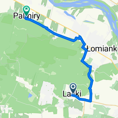
Running route, 7.8 km over Father's Mountain.
- -:--
- Duration
- 7.9 km
- Distance
- 28 m
- Ascent
- 43 m
- Descent
- ---
- Avg. speed
- ---
- Max. altitude
Route quality
Waytypes & surfaces along the route
Waytypes
Path
5.1 km
(65 %)
Track
2.8 km
(35 %)
Surfaces
Unpaved
3.3 km
(42 %)
Ground
2.7 km
(34 %)
Unpaved (undefined)
0.6 km
(7 %)
Continue with Bikemap
Use, edit, or download this cycling route
You would like to ride [run] 7,8 km przez G贸r臋 Ojca or customize it for your own trip? Here is what you can do with this Bikemap route:
Free features
- Save this route as favorite or in collections
- Copy & plan your own version of this route
- Sync your route with Garmin or Wahoo
Premium features
Free trial for 3 days, or one-time payment. More about Bikemap Premium.
- Navigate this route on iOS & Android
- Export a GPX / KML file of this route
- Create your custom printout (try it for free)
- Download this route for offline navigation
Discover more Premium features.
Get Bikemap PremiumFrom our community
Other popular routes starting in Izabelin
kampinos 1- Distance
- 6.5 km
- Ascent
- 18 m
- Descent
- 17 m
- Location
- Izabelin, Masovian Voivodeship, Poland
Pocztowa 6, Laski do Grupy Kampinos 2, Palmiry- Distance
- 16.9 km
- Ascent
- 39 m
- Descent
- 53 m
- Location
- Izabelin, Masovian Voivodeship, Poland
Kampinoski Szlak Rowerowy - full- Distance
- 135.6 km
- Ascent
- 129 m
- Descent
- 130 m
- Location
- Izabelin, Masovian Voivodeship, Poland
[run] 7,8 km przez G贸r臋 Ojca- Distance
- 7.9 km
- Ascent
- 28 m
- Descent
- 43 m
- Location
- Izabelin, Masovian Voivodeship, Poland
KSR - full- Distance
- 135.2 km
- Ascent
- 155 m
- Descent
- 155 m
- Location
- Izabelin, Masovian Voivodeship, Poland
Droga Bez Nazwy do Pocztowa- Distance
- 2.7 km
- Ascent
- 3 m
- Descent
- 3 m
- Location
- Izabelin, Masovian Voivodeship, Poland
kempinos- Distance
- 36.2 km
- Ascent
- 1,348 m
- Descent
- 1,348 m
- Location
- Izabelin, Masovian Voivodeship, Poland
Kampinoski Park Narodowy- Distance
- 22.3 km
- Ascent
- 64 m
- Descent
- 65 m
- Location
- Izabelin, Masovian Voivodeship, Poland
Open it in the app
![[run] 7,8 km przez G贸r臋 Ojca](/_next/static/media/contour-lines-light-large-wide.01ab1563.jpg)
![[run] 7,8 km przez G贸r臋 Ojca](https://media.bikemap.net/routes/2880758/staticmaps/in_a01546f4-1a9f-44bf-a089-d0e1ac6acee6_694x400_bikemap-2021-3D-static.png)