

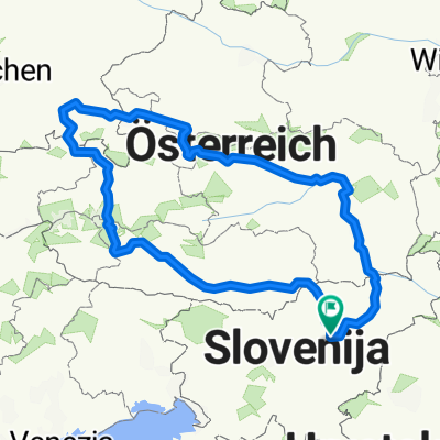
PO DOLENJSKEM
A cycling route starting in Žalec, Občina Žalec, Slovenia.
Overview
About this route
HILLY ROUTE, PARTIALLY ALONG THE KOLPA AND THROUGH BEAR COUNTRY
- -:--
- Duration
- 361.3 km
- Distance
- 2,296 m
- Ascent
- 2,296 m
- Descent
- ---
- Avg. speed
- ---
- Max. altitude

Route quality
Waytypes & surfaces along the route
Waytypes
Road
180.7 km
(50 %)
Quiet road
32.5 km
(9 %)
Undefined
148.1 km
(41 %)
Surfaces
Paved
263.8 km
(73 %)
Asphalt
252.9 km
(70 %)
Paved (undefined)
10.8 km
(3 %)
Undefined
97.6 km
(27 %)
Route highlights
Points of interest along the route
Point of interest after 78.2 km
GPS: 45,838081°N 15,238384°E Kamp Otočec Grajska cesta 2 8222 Otočec +386 (0)40 466 589
Point of interest after 116.7 km
Kamp Podzemelj ob Kolpi, Bela krajina Škrilje 11, Gradac, Slovenija kamp-podzemelj.si (07) 306 95 72
Point of interest after 144.1 km
Kamp Kolpa Vinica 19, Vinica, Slovenija kamp-kolpa.si
Point of interest after 186.2 km
Kamp Žaga Sebastjan Samsa s.p. Gorenja Žaga 1a, Kostel, Slovenija (01) 894 22 91
Point of interest after 186.8 km
Grad Kostel Kostel, Slovenija
Point of interest after 255.3 km
PRI JANEZOVEM ZNANCU MOTORISTU NA TRAVNIKU LOJZE STERLE
Point of interest after 275.4 km
TU SVA PRESPALA
Continue with Bikemap
Use, edit, or download this cycling route
You would like to ride PO DOLENJSKEM or customize it for your own trip? Here is what you can do with this Bikemap route:
Free features
- Save this route as favorite or in collections
- Copy & plan your own version of this route
- Split it into stages to create a multi-day tour
- Sync your route with Garmin or Wahoo
Premium features
Free trial for 3 days, or one-time payment. More about Bikemap Premium.
- Navigate this route on iOS & Android
- Export a GPX / KML file of this route
- Create your custom printout (try it for free)
- Download this route for offline navigation
Discover more Premium features.
Get Bikemap PremiumFrom our community
Other popular routes starting in Žalec
 Maraton Zelene doline
- Distance
- 68.5 km
- Ascent
- 1,225 m
- Descent
- 741 m
- Location
- Žalec, Občina Žalec, Slovenia
 Zicer - Kraljevska 2022 (Žalec-Griže-Prebold-Dom pod Reško planino-Podmeja-Mrzlica-Žalec)
- Distance
- 49.9 km
- Ascent
- 1,346 m
- Descent
- 1,347 m
- Location
- Žalec, Občina Žalec, Slovenia
 GrossGlockner Ciril
- Distance
- 952 km
- Ascent
- 3,159 m
- Descent
- 3,158 m
- Location
- Žalec, Občina Žalec, Slovenia
 Kolesarjenje po Spodnji Savinjski dolini
- Distance
- 50.6 km
- Ascent
- 269 m
- Descent
- 269 m
- Location
- Žalec, Občina Žalec, Slovenia
 Restful route in Žalec
- Distance
- 25.5 km
- Ascent
- 448 m
- Descent
- 469 m
- Location
- Žalec, Občina Žalec, Slovenia
 PO DOLENJSKEM
- Distance
- 356.6 km
- Ascent
- 2,290 m
- Descent
- 2,290 m
- Location
- Žalec, Občina Žalec, Slovenia
 TURA 2024 VIŠARJE
- Distance
- 478.3 km
- Ascent
- 8,471 m
- Descent
- 8,469 m
- Location
- Žalec, Občina Žalec, Slovenia
 Usrano jezero
- Distance
- 698.3 km
- Ascent
- 502 m
- Descent
- 475 m
- Location
- Žalec, Občina Žalec, Slovenia
Open it in the app