

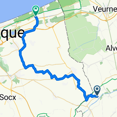
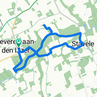
pollinkhove-brakel.parike bivak-112km
A cycling route starting in Alveringem, Flemish Region, Belgium.
Overview
About this route
2nd stage
- -:--
- Duration
- 111.7 km
- Distance
- 456 m
- Ascent
- 390 m
- Descent
- ---
- Avg. speed
- ---
- Max. altitude

Route quality
Waytypes & surfaces along the route
Waytypes
Quiet road
65.9 km
(59 %)
Road
20.1 km
(18 %)
Surfaces
Paved
68.1 km
(61 %)
Unpaved
3.3 km
(3 %)
Asphalt
54.7 km
(49 %)
Concrete
13.4 km
(12 %)
Route highlights
Points of interest along the route
Accommodation after 111.7 km
GPS N 50 46.569 E 3 48.520 paalkampeerplaats Brouwierweide.
Continue with Bikemap
Use, edit, or download this cycling route
You would like to ride pollinkhove-brakel.parike bivak-112km or customize it for your own trip? Here is what you can do with this Bikemap route:
Free features
- Save this route as favorite or in collections
- Copy & plan your own version of this route
- Split it into stages to create a multi-day tour
- Sync your route with Garmin or Wahoo
Premium features
Free trial for 3 days, or one-time payment. More about Bikemap Premium.
- Navigate this route on iOS & Android
- Export a GPX / KML file of this route
- Create your custom printout (try it for free)
- Download this route for offline navigation
Discover more Premium features.
Get Bikemap PremiumFrom our community
Other popular routes starting in Alveringem
 polinkhove - 43.2
- Distance
- 43.2 km
- Ascent
- 72 m
- Descent
- 72 m
- Location
- Alveringem, Flemish Region, Belgium
 20160622_094445.gpx
- Distance
- 32.7 km
- Ascent
- 5 m
- Descent
- 10 m
- Location
- Alveringem, Flemish Region, Belgium
 20160622_Heen.gpx
- Distance
- 30.4 km
- Ascent
- 8 m
- Descent
- 14 m
- Location
- Alveringem, Flemish Region, Belgium
 Beveren-Zuytcoote.gpx
- Distance
- 32.1 km
- Ascent
- 8 m
- Descent
- 14 m
- Location
- Alveringem, Flemish Region, Belgium
 Beveren a/d Ijzer - Oost-Cappel - Rexpoëde - Warhem - Hondschoote - Leisele 18jul23
- Distance
- 26.6 km
- Ascent
- 55 m
- Descent
- 55 m
- Location
- Alveringem, Flemish Region, Belgium
 Avondrit: Hondschoote - Le Kromenhouck - Uxem - Ghyvelde
- Distance
- 22.1 km
- Ascent
- 17 m
- Descent
- 19 m
- Location
- Alveringem, Flemish Region, Belgium
 Roesbruggestraat 19, Alveringem naar Roesbruggestraat 19, Alveringem
- Distance
- 8.5 km
- Ascent
- 8 m
- Descent
- 10 m
- Location
- Alveringem, Flemish Region, Belgium
 LF6 Vl Fietsroute
- Distance
- 563.5 km
- Ascent
- 2,550 m
- Descent
- 2,552 m
- Location
- Alveringem, Flemish Region, Belgium
Open it in the app