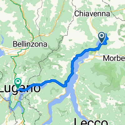
120730 passo san marco
- 97.8 km
- 1,806 m
- 1,806 m
- Verceia, Lombardy, Italy
A cycling route starting in Verceia, Lombardy, Italy.
Overview
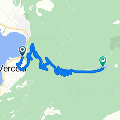
L'Oasi Pian di Spagna Lago di Mezzola.
Cosa c'e' di piu' bello di far conoscere a chi ama la natura,la storia,le tradizioni,le leggende, di questo bellissimo territorio. Ed ecco la nostra idea...! Scopriamo insieme L' Oasi Pian di Spagna e il Lago di Mezzola in sella alla bicicletta. Il nostro itinerario vuole far assaporare il gusto di pedalare immerso in un ambiente unico nel suo genere, abbracciati dalle montagne e cullati dalle calme acque del Lago. Partenza dall' agriturismo LA FIORIDA, seguiamo il sentiero Valtellina attraversando L' Oasi del Pian di Spagna, arriviamo a Dascio (15 km ), qui, chi vuole, puo' salire al belvedere per scattare qualche foto al bellissimo panorama.(50mt.dsl). Scendiamo al porticciolo, dove Gianni , in barca, ci portera' a scoprire gli angoli piu' intimi del Lago di Mezzola, tra questi il tempietto di epoca romana San Fedelino. Terminata la visita sbarchiamo a Novate Mezzola dove ci attendera' un gustoso pranzo con i sapori della Valtellina. Dopo un meritato riposo, si ritorna all' agriturismo LA FIORIDA (18 KM) disegnando un anello attorno al Lago di MezzolaRoute quality
Quiet road
5.4 km
(44 %)
Cycleway
3.9 km
(32 %)
Paved
11.8 km
(96 %)
Asphalt
11.7 km
(95 %)
Paved (undefined)
0.1 km
(1 %)
Undefined
0.5 km
(4 %)
Continue with Bikemap
You would like to ride 9° 26' 33,6"E, 46° 11' 05,4"N or customize it for your own trip? Here is what you can do with this Bikemap route:
Free trial for 3 days, or one-time payment. More about Bikemap Premium.
Discover more Premium features.
Get Bikemap PremiumFrom our community
Open it in the app