

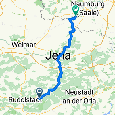
Weissenburg - Mötzelbach - Kuhfraß - Großkochberg - Kirchhasel - Weissenburg
A cycling route starting in Herschdorf, Thuringia, Germany.
Overview
About this route
Hardly any gastronomy from November to March
- -:--
- Duration
- 26.6 km
- Distance
- 527 m
- Ascent
- 519 m
- Descent
- ---
- Avg. speed
- ---
- Max. altitude
Route quality
Waytypes & surfaces along the route
Waytypes
Track
10.6 km
(40 %)
Road
6.6 km
(25 %)
Surfaces
Paved
10.4 km
(39 %)
Unpaved
10.4 km
(39 %)
Asphalt
9 km
(34 %)
Gravel
4 km
(15 %)
Route highlights
Points of interest along the route
Accommodation after 0 km
Continue with Bikemap
Use, edit, or download this cycling route
You would like to ride Weissenburg - Mötzelbach - Kuhfraß - Großkochberg - Kirchhasel - Weissenburg or customize it for your own trip? Here is what you can do with this Bikemap route:
Free features
- Save this route as favorite or in collections
- Copy & plan your own version of this route
- Sync your route with Garmin or Wahoo
Premium features
Free trial for 3 days, or one-time payment. More about Bikemap Premium.
- Navigate this route on iOS & Android
- Export a GPX / KML file of this route
- Create your custom printout (try it for free)
- Download this route for offline navigation
Discover more Premium features.
Get Bikemap PremiumFrom our community
Other popular routes starting in Herschdorf
 7. Uhstädt-Eßbach-Walsburg (BUS)
- Distance
- 67.5 km
- Ascent
- 762 m
- Descent
- 654 m
- Location
- Herschdorf, Thuringia, Germany
 Route von Weißen 3–5, Uhlstädt-Kirchhasel
- Distance
- 71.9 km
- Ascent
- 791 m
- Descent
- 753 m
- Location
- Herschdorf, Thuringia, Germany
 Weissenburg -Kienberg - Partschefeld - Uhlstädt - Weissenbach- Weissenburg
- Distance
- 18.3 km
- Ascent
- 458 m
- Descent
- 454 m
- Location
- Herschdorf, Thuringia, Germany
 Weissenburg - Kirchenruine Töpfersdorf - Friedbach - Hütten - Herschfeld - Friedbach - Weißenbachtal - Weißenburg
- Distance
- 22.8 km
- Ascent
- 521 m
- Descent
- 503 m
- Location
- Herschdorf, Thuringia, Germany
 Weißbach
- Distance
- 25.6 km
- Ascent
- 595 m
- Descent
- 585 m
- Location
- Herschdorf, Thuringia, Germany
 Hütten
- Distance
- 49.2 km
- Ascent
- 492 m
- Descent
- 486 m
- Location
- Herschdorf, Thuringia, Germany
 Weissenburg - Brandberg - Kolkwitz - Weissenburg
- Distance
- 9 km
- Ascent
- 329 m
- Descent
- 304 m
- Location
- Herschdorf, Thuringia, Germany
 Weissenburg - Mötzelbach - Kuhfraß - Großkochberg - Kirchhasel - Weissenburg
- Distance
- 26.6 km
- Ascent
- 527 m
- Descent
- 519 m
- Location
- Herschdorf, Thuringia, Germany
Open it in the app