

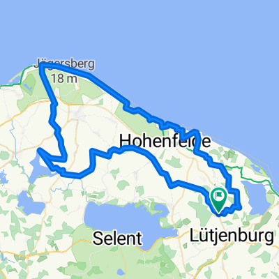
Richtung Probstei
A cycling route starting in Panker, Schleswig-Holstein, Germany.
Overview
About this route
Start ist der Strandparkplatz Behrensdorf, es geht über Kembs nach Satjendorf, Emkendorf, Tröndel, Gleschendorf, Schwartbuck, Schmoel an den Hohenfelder Strand
- -:--
- Duration
- 37.3 km
- Distance
- 134 m
- Ascent
- 134 m
- Descent
- ---
- Avg. speed
- ---
- Max. altitude

Continue with Bikemap
Use, edit, or download this cycling route
You would like to ride Richtung Probstei or customize it for your own trip? Here is what you can do with this Bikemap route:
Free features
- Save this route as favorite or in collections
- Copy & plan your own version of this route
- Sync your route with Garmin or Wahoo
Premium features
Free trial for 3 days, or one-time payment. More about Bikemap Premium.
- Navigate this route on iOS & Android
- Export a GPX / KML file of this route
- Create your custom printout (try it for free)
- Download this route for offline navigation
Discover more Premium features.
Get Bikemap PremiumFrom our community
Other popular routes starting in Panker
 Die Ostsee in SH Abschnitt 8 (22,0 km)
- Distance
- 21.9 km
- Ascent
- 89 m
- Descent
- 89 m
- Location
- Panker, Schleswig-Holstein, Germany
 Windmühlen und Strand
- Distance
- 67.6 km
- Ascent
- 192 m
- Descent
- 195 m
- Location
- Panker, Schleswig-Holstein, Germany
 05-02 Auf zur Insel Fehmarn
- Distance
- 79.9 km
- Ascent
- 147 m
- Descent
- 163 m
- Location
- Panker, Schleswig-Holstein, Germany
 Jahresabschlussfahrt
- Distance
- 30.2 km
- Ascent
- 202 m
- Descent
- 202 m
- Location
- Panker, Schleswig-Holstein, Germany
 Gut Panker - Hessenstein - Schönberger Strand Gut Panker
- Distance
- 42.7 km
- Ascent
- 195 m
- Descent
- 195 m
- Location
- Panker, Schleswig-Holstein, Germany
 NordOstsee5A
- Distance
- 76.9 km
- Ascent
- 167 m
- Descent
- 184 m
- Location
- Panker, Schleswig-Holstein, Germany
 Einfache Fahrt in
- Distance
- 44.4 km
- Ascent
- 295 m
- Descent
- 296 m
- Location
- Panker, Schleswig-Holstein, Germany
 Behrensdorf
- Distance
- 28 km
- Ascent
- 157 m
- Descent
- 131 m
- Location
- Panker, Schleswig-Holstein, Germany
Open it in the app