

R4 – Auf archäologischen Spuren
A cycling route starting in Blekendorf, Schleswig-Holstein, Germany.
Overview
About this route
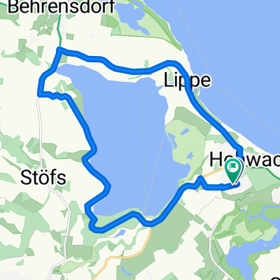
<p><strong>Route:</strong> Sehlendorf - Hohwacht - Hassberg - Futterkamp - Kaköhl - Sehlendorf <strong>Highlights / Tips along the route:</strong> Sehlendorfer Strand, beach bistros at Sehlendorfer Strand, NSG Sehlendorfer Binnensee with bird observation platform, bay of Alt-Hohwacht, mini-golf course, fish smokehouse and beach bistros in Alt-Hohwacht, golf course Hohwachter Bucht with restaurant 'Zeitlos', Bronze Age burial mound, café at Steinkamp, teaching and experimental farm Futterkamp, historic long beds in Futterkamp, Kaköhl - farm shop Maßmann, bistro B 202, megalithic tombs/structures near Kaköhl <strong>Detailed Route Description:</strong></p>
<p>Starting point: Sehlendorf, left parking lot at Sehlendorfer Strand, and from there left into the nature reserve Sehlendorfer Binnensee, right the observation platform for a view into the reserve and the bay, continue over the bridge. Behind the bridge, there is another observation platform on the left for resting and observing. (Some benches with beautiful views invite you to rest.)</p>
<p>In Hohwacht, pass the mini-golf course, possibly make a small shopping stop at the fish smokehouse Kruse and then follow right down the beach road. At the end of the street, there are three nice beach bistros to refuel. In front of the beach hotel, the path goes left up to the cliff. Passing the "Hohwachter Ausguck", follow the cliff path. Here, too, there are several options for refreshments (Tom's Hütte, Nudelladen, Hotel Hohe Wacht in the spa park). At the end of the cliff, you turn left onto Seestraße. At the intersection, turn right towards Haßberg and continue along Eichenallee towards Lütjenburg. At the golf course, turn left before the parking lot and follow the path to the <strong>prehistoric</strong> <strong>long beds on the Ruserberg</strong>. Continue to Futterkamp. You cross the B202 and stay left towards Oldenburg. (Shortly thereafter, you have the opportunity to turn right to Café am Steinkamp and try delicious homemade cake.)</p>
<p>Then follow the bike path along the B202 towards Kaköhl, passing the teaching and research institute. Another rest stop is available in Kaköhl at the farm shop 'Maßmann' or at bistro B 202. (Shortcut: just before the bistro, you can now turn left to return to Sehlendorf). Continue on the road towards Oldenburg for about 2 km past Kaköhl. At the first house on the right, a sign will guide you up a field path 200 m uphill to three prehistoric graves on the hilltop (<strong>megalithic structures at Buschkate</strong>). If you continue along the bike path on the B 202 for about 1 km towards Oldenburg, then choose the tar road to the left towards Sehlendorf, you can enjoy the breathtaking view over Hohwachter Bucht and return to Sehlendorf.</p>
<p>In Sehlendorf, you have the opportunity to refuel at the designated campsites and their kiosks! Following the route at the height of Sehlendorfer Binnensee, the terrace of the restaurant 'Packhus' offers a place to rest, or you could head to the Tourist Information for a 'Sundowner' at the beach bistros at Sehlendorfer Strand.</p>
Translated, show original (German)- -:--
- Duration
- 18.5 km
- Distance
- 102 m
- Ascent
- 102 m
- Descent
- ---
- Avg. speed
- ---
- Max. altitude

Route quality
Waytypes & surfaces along the route
Waytypes
Path
7.2 km
(39 %)
Quiet road
3.9 km
(21 %)
Surfaces
Paved
11.9 km
(64 %)
Unpaved
3.7 km
(20 %)
Asphalt
11.9 km
(64 %)
Gravel
3 km
(16 %)
Route highlights
Points of interest along the route
Point of interest after 7.7 km
Langbetten auf dem Ruserberg
Point of interest after 8.7 km
Obst-Erlebnis-Garten
Point of interest after 14.2 km
drei Megalithanlagen bei Kaköhl
Point of interest after 18.5 km
Touristinfo Sehlendorfer Strand
Continue with Bikemap
Use, edit, or download this cycling route
You would like to ride R4 – Auf archäologischen Spuren or customize it for your own trip? Here is what you can do with this Bikemap route:
Free features
- Save this route as favorite or in collections
- Copy & plan your own version of this route
- Sync your route with Garmin or Wahoo
Premium features
Free trial for 3 days, or one-time payment. More about Bikemap Premium.
- Navigate this route on iOS & Android
- Export a GPX / KML file of this route
- Create your custom printout (try it for free)
- Download this route for offline navigation
Discover more Premium features.
Get Bikemap PremiumFrom our community
Other popular routes starting in Blekendorf
 Strandstraße 11, Hohwacht (Ostsee) nach Sarkwitzer Straße 19, Ratekau
- Distance
- 94.6 km
- Ascent
- 580 m
- Descent
- 561 m
- Location
- Blekendorf, Schleswig-Holstein, Germany
 R2 - Urige Dörfer, herrschaftliche Güter und erlebnisreiche Aussichten
- Distance
- 27.1 km
- Ascent
- 154 m
- Descent
- 152 m
- Location
- Blekendorf, Schleswig-Holstein, Germany
 Hohwacht Rundtour
- Distance
- 9.4 km
- Ascent
- 54 m
- Descent
- 53 m
- Location
- Blekendorf, Schleswig-Holstein, Germany
 Rögenkamp 36A nach Rögenkamp
- Distance
- 24.4 km
- Ascent
- 192 m
- Descent
- 237 m
- Location
- Blekendorf, Schleswig-Holstein, Germany
 12_Hohwacht – Heiligenhafen – Burg auf Fehmarn
- Distance
- 104.4 km
- Ascent
- 127 m
- Descent
- 135 m
- Location
- Blekendorf, Schleswig-Holstein, Germany
 Rögenkamp nach Rögenkamp
- Distance
- 5.6 km
- Ascent
- 109 m
- Descent
- 124 m
- Location
- Blekendorf, Schleswig-Holstein, Germany
 Radwanderweg zu archäologischen Denkmälern rund um Lütjenburg
- Distance
- 22.6 km
- Ascent
- 131 m
- Descent
- 129 m
- Location
- Blekendorf, Schleswig-Holstein, Germany
 Hohwacht Binnensee
- Distance
- 14.9 km
- Ascent
- 84 m
- Descent
- 83 m
- Location
- Blekendorf, Schleswig-Holstein, Germany
Open it in the app