

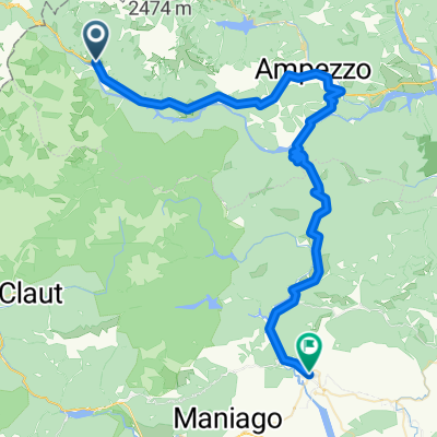
Forni di Sopra - Piniei, percorso mountain bike
A cycling route starting in Vico, Friuli Venezia Giulia, Italy.
Overview
About this route
Easy valley route with a fun single track in the woods (avoidable by returning along the forest road). You can also extend the route by continuing towards Val Rovadia: once you reach the valley, you can climb for a long stretch until the end of the rideable section. We recommend continuing on foot to the start of the actual climb where, on your left, there is a beautiful waterfall. The Val Rovadia is beautiful and wild, we are in the Natural Park of the Friulian Dolomites, a UNESCO World Heritage Site.
- -:--
- Duration
- 22.4 km
- Distance
- 327 m
- Ascent
- 327 m
- Descent
- ---
- Avg. speed
- ---
- Max. altitude

Continue with Bikemap
Use, edit, or download this cycling route
You would like to ride Forni di Sopra - Piniei, percorso mountain bike or customize it for your own trip? Here is what you can do with this Bikemap route:
Free features
- Save this route as favorite or in collections
- Copy & plan your own version of this route
- Sync your route with Garmin or Wahoo
Premium features
Free trial for 3 days, or one-time payment. More about Bikemap Premium.
- Navigate this route on iOS & Android
- Export a GPX / KML file of this route
- Create your custom printout (try it for free)
- Download this route for offline navigation
Discover more Premium features.
Get Bikemap PremiumFrom our community
Other popular routes starting in Vico
 Malga Tragonia/Tartoi
- Distance
- 13.2 km
- Ascent
- 1,029 m
- Descent
- 228 m
- Location
- Vico, Friuli Venezia Giulia, Italy
 sella Bivera da Casera Razzo
- Distance
- 14.4 km
- Ascent
- 1,945 m
- Descent
- 1,982 m
- Location
- Vico, Friuli Venezia Giulia, Italy
 Zoncolan da Ovaro
- Distance
- 111.8 km
- Ascent
- 2,177 m
- Descent
- 2,177 m
- Location
- Vico, Friuli Venezia Giulia, Italy
 Forni di Sopra-Meduno
- Distance
- 63.1 km
- Ascent
- 1,317 m
- Descent
- 1,925 m
- Location
- Vico, Friuli Venezia Giulia, Italy
 forni di sopra
- Distance
- 5.4 km
- Ascent
- 590 m
- Descent
- 158 m
- Location
- Vico, Friuli Venezia Giulia, Italy
 Forni di Sopra - Tartoi - Ridona
- Distance
- 14.4 km
- Ascent
- 802 m
- Descent
- 805 m
- Location
- Vico, Friuli Venezia Giulia, Italy
 SS52 22, Forni di Sopra to Strada senza nome, Forni di sopra
- Distance
- 4.2 km
- Ascent
- 594 m
- Descent
- 19 m
- Location
- Vico, Friuli Venezia Giulia, Italy
 Forni di Sopra - Piniei, percorso mountain bike
- Distance
- 22.4 km
- Ascent
- 327 m
- Descent
- 327 m
- Location
- Vico, Friuli Venezia Giulia, Italy
Open it in the app