
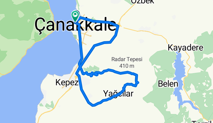
Liman-Yangın Gözetleme kulesi-Radar tepesi-liman
A cycling route starting in Çanakkale, Çanakkale Province, Republic of Türkiye.
Overview
About this route
Moderate fitness level
- -:--
- Duration
- 34 km
- Distance
- 480 m
- Ascent
- 481 m
- Descent
- ---
- Avg. speed
- ---
- Max. altitude

Route highlights
Points of interest along the route
Point of interest after 6.5 km
Yangın Gözetleme Kulesi
Point of interest after 11.4 km
Askeriye
Continue with Bikemap
Use, edit, or download this cycling route
You would like to ride Liman-Yangın Gözetleme kulesi-Radar tepesi-liman or customize it for your own trip? Here is what you can do with this Bikemap route:
Free features
- Save this route as favorite or in collections
- Copy & plan your own version of this route
- Sync your route with Garmin or Wahoo
Premium features
Free trial for 3 days, or one-time payment. More about Bikemap Premium.
- Navigate this route on iOS & Android
- Export a GPX / KML file of this route
- Create your custom printout (try it for free)
- Download this route for offline navigation
Discover more Premium features.
Get Bikemap PremiumFrom our community
Other popular routes starting in Çanakkale
 manyaklık
- Distance
- 29.6 km
- Ascent
- 1,101 m
- Descent
- 206 m
- Location
- Çanakkale, Çanakkale Province, Republic of Türkiye
 Çanakalan-Elmacık-Yağcılar-Sarıcaeli
- Distance
- 59.2 km
- Ascent
- 813 m
- Descent
- 813 m
- Location
- Çanakkale, Çanakkale Province, Republic of Türkiye
 Balaban Yangın Gözetleme Kulesi
- Distance
- 76.4 km
- Ascent
- 891 m
- Descent
- 891 m
- Location
- Çanakkale, Çanakkale Province, Republic of Türkiye
 Alternatif Yarımada Turu
- Distance
- 46.3 km
- Ascent
- 537 m
- Descent
- 541 m
- Location
- Çanakkale, Çanakkale Province, Republic of Türkiye
 Liman-Yangın Gözetleme kulesi-Radar tepesi-liman
- Distance
- 34 km
- Ascent
- 480 m
- Descent
- 481 m
- Location
- Çanakkale, Çanakkale Province, Republic of Türkiye
 Salavat-Çiftlikdere
- Distance
- 46.7 km
- Ascent
- 542 m
- Descent
- 542 m
- Location
- Çanakkale, Çanakkale Province, Republic of Türkiye
 Obaköy
- Distance
- 44.7 km
- Ascent
- 661 m
- Descent
- 655 m
- Location
- Çanakkale, Çanakkale Province, Republic of Türkiye
 kilitbahir-eceabat
- Distance
- 22.4 km
- Ascent
- 305 m
- Descent
- 306 m
- Location
- Çanakkale, Çanakkale Province, Republic of Türkiye
Open it in the app