

Overview
About this route
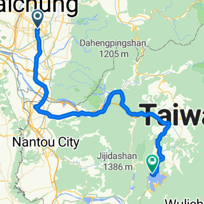
Totally flat and smooth surface the whole way. Make sure to stop at GB Cafe on the way.
Google Maps for GB Cafe: 504, Taiwan, Changhua County, Xiushui Township, 枋林巷1號- -:--
- Duration
- 94.6 km
- Distance
- 69 m
- Ascent
- 112 m
- Descent
- ---
- Avg. speed
- ---
- Max. altitude
Part of
Taipei to Kaohsiung
3 stages
Route quality
Waytypes & surfaces along the route
Waytypes
Quiet road
18.9 km
(20 %)
Access road
18 km
(19 %)
Surfaces
Paved
34.1 km
(36 %)
Asphalt
32.2 km
(34 %)
Paved (undefined)
1.9 km
(2 %)
Undefined
60.6 km
(64 %)
Continue with Bikemap
Use, edit, or download this cycling route
You would like to ride Day 3 - Taichung to Chiayi or customize it for your own trip? Here is what you can do with this Bikemap route:
Free features
- Save this route as favorite or in collections
- Copy & plan your own version of this route
- Split it into stages to create a multi-day tour
- Sync your route with Garmin or Wahoo
Premium features
Free trial for 3 days, or one-time payment. More about Bikemap Premium.
- Navigate this route on iOS & Android
- Export a GPX / KML file of this route
- Create your custom printout (try it for free)
- Download this route for offline navigation
Discover more Premium features.
Get Bikemap PremiumFrom our community
Other popular routes starting in Taichung
 日月潭 平易近人 路線
- Distance
- 149.1 km
- Ascent
- 1,064 m
- Descent
- 1,062 m
- Location
- Taichung, Taiwan, Taiwan
 牛角坑大石壁
- Distance
- 12 km
- Ascent
- 465 m
- Descent
- 463 m
- Location
- Taichung, Taiwan, Taiwan
 台中-日月潭
- Distance
- 72.4 km
- Ascent
- 1,089 m
- Descent
- 559 m
- Location
- Taichung, Taiwan, Taiwan
 中興嶺 : 廍子路 to 中興嶺郵局
- Distance
- 10.9 km
- Ascent
- 486 m
- Descent
- 115 m
- Location
- Taichung, Taiwan, Taiwan
 台中-日月潭
- Distance
- 157.8 km
- Ascent
- 1,048 m
- Descent
- 1,048 m
- Location
- Taichung, Taiwan, Taiwan
 一日一望高 可以遠離醫生
- Distance
- 36 km
- Ascent
- 334 m
- Descent
- 311 m
- Location
- Taichung, Taiwan, Taiwan
 竹仔坑虹橋_牛角坑自行車道_後壁農路_光興路
- Distance
- 13.2 km
- Ascent
- 615 m
- Descent
- 622 m
- Location
- Taichung, Taiwan, Taiwan
 136
136- Distance
- 19.3 km
- Ascent
- 754 m
- Descent
- 297 m
- Location
- Taichung, Taiwan, Taiwan
Open it in the app