

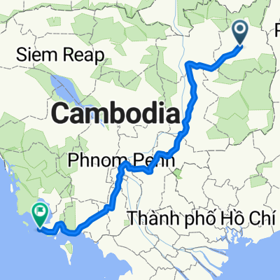
J029 - vendredi 06 février 2015 - Ban Lung ( Cambodge ) - Mook Den ( Vietnam )
A cycling route starting in Banlung, Ratanakiri, Cambodia.
Overview
About this route
J029 - Friday, February 06, 2015 - Ban Lung (Cambodia) - Mook Den (Vietnam) - 87.32 km - average 12.87 km/h - ascent 737 meters - max slope 6 % - descent 685 meters - max descent slope 10 %.
- -:--
- Duration
- 85.3 km
- Distance
- 440 m
- Ascent
- 400 m
- Descent
- ---
- Avg. speed
- ---
- Max. altitude
Route quality
Waytypes & surfaces along the route
Waytypes
Cycleway
13.6 km
(16 %)
Quiet road
6 km
(7 %)
Surfaces
Paved
10.2 km
(12 %)
Asphalt
10.2 km
(12 %)
Undefined
75 km
(88 %)
Continue with Bikemap
Use, edit, or download this cycling route
You would like to ride J029 - vendredi 06 février 2015 - Ban Lung ( Cambodge ) - Mook Den ( Vietnam ) or customize it for your own trip? Here is what you can do with this Bikemap route:
Free features
- Save this route as favorite or in collections
- Copy & plan your own version of this route
- Split it into stages to create a multi-day tour
- Sync your route with Garmin or Wahoo
Premium features
Free trial for 3 days, or one-time payment. More about Bikemap Premium.
- Navigate this route on iOS & Android
- Export a GPX / KML file of this route
- Create your custom printout (try it for free)
- Download this route for offline navigation
Discover more Premium features.
Get Bikemap PremiumFrom our community
Other popular routes starting in Banlung
 banlung-sihanoukville
- Distance
- 728.5 km
- Ascent
- 287 m
- Descent
- 548 m
- Location
- Banlung, Ratanakiri, Cambodia
 33, Krong Ban Lung to 33, Krong Ban Lung
- Distance
- 12 km
- Ascent
- 61 m
- Descent
- 64 m
- Location
- Banlung, Ratanakiri, Cambodia
 ៣៣, ក្រុងបានលុង to ៣៣, ក្រុងបានលុង
- Distance
- 1.8 km
- Ascent
- 0 m
- Descent
- 22 m
- Location
- Banlung, Ratanakiri, Cambodia
 33, Krong Ban Lung to National Road 76
- Distance
- 51.2 km
- Ascent
- 270 m
- Descent
- 454 m
- Location
- Banlung, Ratanakiri, Cambodia
 46, Krong Ban Lung to 33, Krong Ban Lung
- Distance
- 6.3 km
- Ascent
- 44 m
- Descent
- 38 m
- Location
- Banlung, Ratanakiri, Cambodia
 46, Krong Ban Lung to 33, Krong Ban Lung
- Distance
- 13.8 km
- Ascent
- 231 m
- Descent
- 207 m
- Location
- Banlung, Ratanakiri, Cambodia
 Boung Kinseng To Office
- Distance
- 1.3 km
- Ascent
- 39 m
- Descent
- 26 m
- Location
- Banlung, Ratanakiri, Cambodia
 Banlung Modukiri 178 km
- Distance
- 175.9 km
- Ascent
- 839 m
- Descent
- 454 m
- Location
- Banlung, Ratanakiri, Cambodia
Open it in the app