Ipartelep utca, Pálháza to Szemlőhegyi út, Bózsva
- 2.8 km
- 186 m
- 171 m
- Sátoraljaújhely, Borsod-Abauj Zemplen county, Hungary
A cycling route starting in Sátoraljaújhely, Borsod-Abauj Zemplen county, Hungary.
Overview
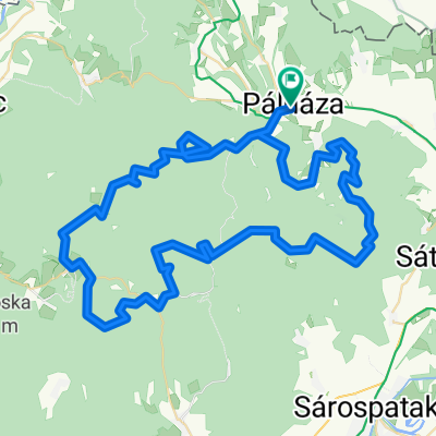
2014 Pünkösdi Huta Tour - Day 2
Day 2 - Saturday in the mountains:
We woke up early, had breakfast, and set off after 9. No car noise, no shouting, just the chirping of birds and the buzzing of insects woven into the stillness. One can sleep for a long time.
Today's plan includes Kőkapu and Füzer.
We rolled down from Nagyhutár on the highway to Kishutára. In Kishután, there was a lot of activity, a rush of preparations. What's going on here? Today is the Pünkösdi Kakas Festival. There will be a chicken goulash cooking competition and an all-day event. We'll have to check it out when we come back.
After Kishuta, we went to Kőkapu. We spent some time here. We sat by the lake and admired the wooden statues. Along the way, we ate strawberries. A little while later, we went back to Kishutára along the same forest road. We now realized that the road towards Kőkapu was climbing as it was easier to roll back. We headed to Pálháza. In Pálháza, there is a bike service. We shopped for the weekend at the shop across the street. You have to be careful in these smaller villages because the shops close early, and one can easily get stuck. So we filled my bag well since there are also no shops open on Sunday and Monday due to the Pentecost celebration. So a couple of extra kilos and we're ready to go.
Here, we were no longer following the bike path. The road also had relatively little traffic. After Filkeházá, we were almost continuously climbing towards Füzer. It will be nice to roll back down this road, we thought. But then we skipped the steepest parts.
Before Füzer, there was a more pleasant climb, which I suppose only we Transdanubian cyclists feel, and we were on top of the village. Great silence, warm, and almost no soul was on the street. We did not go up to the castle. We sat down to rest a bit. We had an ice cream, sampled the strawberry trees and then set off. We heard at the ice cream shop that the Izra Lake in Slovakia was not far away, so we decided to check it out. Almost circling the castle hill, we reached Pusztafalva. Here we asked which road leads to the lake. There were two paths in front of us; which should we choose? We opted for the steeper one. We only discovered this after a few turns. Shame aside, we got off and pushed the machines a bit up the slope. As it was an asphalt road, even in Hungary, the traffic sign showed a 10% incline. We thought we would glide well. We rolled, but now only back, as instead of the ascent a descent sign had been put up. So that descent became an ascent. Oh well, it happens. In a beautiful environment, in the woods, next to the woods, we reached Izra Lake on well-travelled gravel and dirt roads. We anticipated something a bit bigger, but still, some people were swimming, boating, and grilling. After a short break, we started back. Now we rolled on the larger part of the road, and in some places, you could even speed up. To Pálháza, we hardly had to pedal. This pedaling is like cooking. You cook all morning so the family eats everything in 10 minutes. You pedal uphill for hours to glide down in a few minutes. But this rolling will be the reward for pedaling.
In Kishuta, we dropped by the Kakas festival, where invited guests provided the entertainment one after another, while people ate, drank, and had fun. We also spent a little time there. We tasted the chicken goulash, chatted with the locals, then started back to Nagyhutára.
In Nagyhután, we stopped at the pub for a nice cold beer. Here we got to know the locals again, then headed home. We started preparing dinner. There were paprika potatoes in a cauldron. True, it was a bit saltier than in the East, but it was ours.
Second day summary: 55 km, 4 hours 4 minutes
created this 10 years ago
Route quality
Road
20.6 km
(38 %)
Quiet road
16.8 km
(31 %)
Paved
27.2 km
(50 %)
Unpaved
7.6 km
(14 %)
Asphalt
26.6 km
(49 %)
Gravel
7.6 km
(14 %)
Continue with Bikemap
You would like to ride 2014 Pünkösdi Huta Túra - 2. nap or customize it for your own trip? Here is what you can do with this Bikemap route:
Free trial for 3 days, or one-time payment. More about Bikemap Premium.
Discover more Premium features.
Get Bikemap PremiumFrom our community
Open it in the app