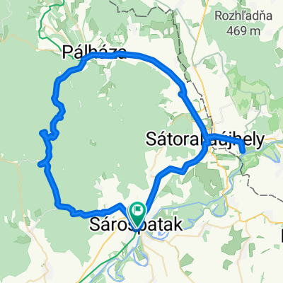
pünkösd túra 2015
A cycling route starting in Sárospatak, Borsod-Abauj Zemplen county, Hungary.
Overview
About this route
pünkösdi túra
(cloned from route 2902037)
- -:--
- Duration
- 126.5 km
- Distance
- 639 m
- Ascent
- 642 m
- Descent
- ---
- Avg. speed
- ---
- Avg. speed
Route quality
Waytypes & surfaces along the route
Waytypes
Busy road
64.7 km
(51 %)
Cycleway
22.4 km
(18 %)
Surfaces
Paved
41.1 km
(33 %)
Unpaved
5.9 km
(5 %)
Asphalt
40.9 km
(32 %)
Ground
4.4 km
(3 %)
Route highlights
Points of interest along the route
Point of interest after 11.6 km
Magyar kálvária (trianon emlékmű)
Point of interest after 14.6 km
zempléni kalandpark
Point of interest after 28.4 km
magyarország legrégebbi kisvasútja itt indul
Accommodation after 30 km
1.nap szállás pálháza
Point of interest after 37.6 km
füzéri vár
Point of interest after 42.7 km
porcelán múzeum, országos kék túra végpontja
Point of interest after 51.7 km
károlyi kastély
Accommodation after 69.7 km
2.nap szállás Gönc
Accommodation after 105.5 km
3.nap szállás Erdőbénye
Continue with Bikemap
Use, edit, or download this cycling route
You would like to ride pünkösd túra 2015 or customize it for your own trip? Here is what you can do with this Bikemap route:
Free features
- Save this route as favorite or in collections
- Copy & plan your own version of this route
- Sync your route with Garmin or Wahoo
Premium features
Free trial for 3 days, or one-time payment. More about Bikemap Premium.
- Navigate this route on iOS & Android
- Export a GPX / KML file of this route
- Create your custom printout (try it for free)
- Download this route for offline navigation
Discover more Premium features.
Get Bikemap PremiumFrom our community
Other popular routes starting in Sárospatak
- Kerek kő 1.
- Distance
- 2.3 km
- Ascent
- 150 m
- Descent
- 21 m
- Location
- Sárospatak, Borsod-Abauj Zemplen county, Hungary
- Szabolcs - újabb 12 település - 190601
- Distance
- 242.3 km
- Ascent
- 75 m
- Descent
- 78 m
- Location
- Sárospatak, Borsod-Abauj Zemplen county, Hungary
- pünkösd túra 2015
- Distance
- 126.5 km
- Ascent
- 639 m
- Descent
- 642 m
- Location
- Sárospatak, Borsod-Abauj Zemplen county, Hungary
- Nagyhuta 0331
- Distance
- 35.1 km
- Ascent
- 550 m
- Descent
- 546 m
- Location
- Sárospatak, Borsod-Abauj Zemplen county, Hungary
- Bringahorda 2017
- Distance
- 139.6 km
- Ascent
- 1,176 m
- Descent
- 1,176 m
- Location
- Sárospatak, Borsod-Abauj Zemplen county, Hungary
- STEREO 10.4 Gerendás-rét - Pálháza
- Distance
- 11.5 km
- Ascent
- 26 m
- Descent
- 304 m
- Location
- Sárospatak, Borsod-Abauj Zemplen county, Hungary
- Patak-Pálháza-Gönc-Pálháza-Patak
- Distance
- 103.2 km
- Ascent
- 470 m
- Descent
- 470 m
- Location
- Sárospatak, Borsod-Abauj Zemplen county, Hungary
- makkos
- Distance
- 52.7 km
- Ascent
- 1,452 m
- Descent
- 1,456 m
- Location
- Sárospatak, Borsod-Abauj Zemplen county, Hungary