

SZT / TBT.Szászfehéregyházi túra szept.13
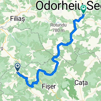
A cycling route starting in Buneşti, Brașov County, Romania.
Overview
About this route
Motorway Szászkeresztúr - Tale - Szászfehérgyháza - Szászbuda - Szászkeresztúr.
- -:--
- Duration
- 37.8 km
- Distance
- 580 m
- Ascent
- 579 m
- Descent
- ---
- Avg. speed
- ---
- Max. altitude

Route quality
Waytypes & surfaces along the route
Waytypes
Cycleway
15.5 km
(41 %)
Track
7.6 km
(20 %)
Surfaces
Paved
8.7 km
(23 %)
Unpaved
11.3 km
(30 %)
Asphalt
8.7 km
(23 %)
Ground
6.4 km
(17 %)
Route highlights
Points of interest along the route

Point of interest after 0 km
Indúlópont a Szászkeresztúri Vártemplom előtt.

Point of interest after 2.9 km
Kapaszkodás a gerincre

Point of interest after 3.7 km
Mesés a környezet...

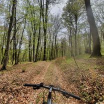
Point of interest after 4.7 km
Biciklizés az erdőben, nagyon kellemes, kiépitett bringaösvényen.

Point of interest after 5.6 km
Pihenő

Point of interest after 6.1 km
Barny downhillben. figyelem ! ez a fotó levédve :)

Point of interest after 7.5 km
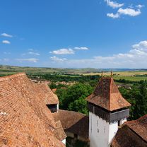
A Mesei vártemplom látogatása

Point of interest after 16.6 km
Erdőn, mezőn, ákron-bokron keresztűl kitartóan hajt a csapat.

Point of interest after 18.1 km
Giorgio meg jómagam és a pánoráma ;)
Point of interest after 19.6 km
ITT NEM JÁRTUNK, DE JÓ LEHET !

Point of interest after 21.7 km
Lendületben maradni !

Point of interest after 24.8 km
a Szf.házi vártemplom belülről

Point of interest after 25.6 km
Megérkezés Szászfehéregyházára

Point of interest after 25.7 km
Szászfehéregyháza, és a Vártemplom kertje, ahol vártak a Nagy fiúk !

Point of interest after 25.8 km
Kultúrálódunk.

Point of interest after 25.8 km
Csoportfotó a Vártemplom kapujában

Point of interest after 36.3 km
Levezető tekerés a "Scroafa" patak mentén

Point of interest after 36.7 km
A levezető szakasz.
Continue with Bikemap
Use, edit, or download this cycling route
You would like to ride SZT / TBT.Szászfehéregyházi túra szept.13 or customize it for your own trip? Here is what you can do with this Bikemap route:
Free features
- Save this route as favorite or in collections
- Copy & plan your own version of this route
- Sync your route with Garmin or Wahoo
Premium features
Free trial for 3 days, or one-time payment. More about Bikemap Premium.
- Navigate this route on iOS & Android
- Export a GPX / KML file of this route
- Create your custom printout (try it for free)
- Download this route for offline navigation
Discover more Premium features.
Get Bikemap PremiumFrom our community
Other popular routes starting in Buneşti
 Crit - Mesendorf - Viscri
- Distance
- 51.9 km
- Ascent
- 368 m
- Descent
- 360 m
- Location
- Buneşti, Brașov County, Romania
 Circuit Bunesti-Crit-Viscri
- Distance
- 38.4 km
- Ascent
- 484 m
- Descent
- 482 m
- Location
- Buneşti, Brașov County, Romania
 Szaszfold oktoberi vasarnap
- Distance
- 50 km
- Ascent
- 759 m
- Descent
- 763 m
- Location
- Buneşti, Brașov County, Romania
 Criț, Mesendorf, Viscri, Bunesti, Crit
- Distance
- 40 km
- Ascent
- 2,272 m
- Descent
- 2,249 m
- Location
- Buneşti, Brașov County, Romania
 Mesendorf - Sighisoara
- Distance
- 34.6 km
- Ascent
- 419 m
- Descent
- 599 m
- Location
- Buneşti, Brașov County, Romania
 SZT / Szászföldi tekergés másodszori
- Distance
- 32.1 km
- Ascent
- 664 m
- Descent
- 745 m
- Location
- Buneşti, Brașov County, Romania
 Crit Meșendorf Andi Mila
- Distance
- 27.5 km
- Ascent
- 1,137 m
- Descent
- 1,150 m
- Location
- Buneşti, Brașov County, Romania
 Meșendorf, Viscri, Bunesti, Crit, Mesendorf
- Distance
- 48.8 km
- Ascent
- 171 m
- Descent
- 318 m
- Location
- Buneşti, Brașov County, Romania
Open it in the app