

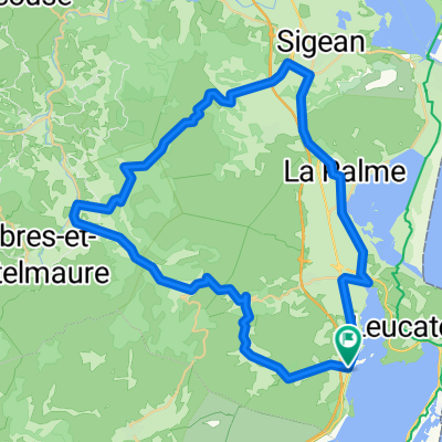
Leucate - Corbières
A cycling route starting in Leucate, Occitanie, France.
Overview
About this route
Leucate - Corbières
- -:--
- Duration
- 75.5 km
- Distance
- 431 m
- Ascent
- 434 m
- Descent
- ---
- Avg. speed
- ---
- Max. altitude

Route quality
Waytypes & surfaces along the route
Waytypes
Path
19.6 km
(26 %)
Road
9.1 km
(12 %)
Surfaces
Paved
36.3 km
(48 %)
Unpaved
2.3 km
(3 %)
Asphalt
31.7 km
(42 %)
Paved (undefined)
2.3 km
(3 %)
Continue with Bikemap
Use, edit, or download this cycling route
You would like to ride Leucate - Corbières or customize it for your own trip? Here is what you can do with this Bikemap route:
Free features
- Save this route as favorite or in collections
- Copy & plan your own version of this route
- Sync your route with Garmin or Wahoo
Premium features
Free trial for 3 days, or one-time payment. More about Bikemap Premium.
- Navigate this route on iOS & Android
- Export a GPX / KML file of this route
- Create your custom printout (try it for free)
- Download this route for offline navigation
Discover more Premium features.
Get Bikemap PremiumFrom our community
Other popular routes starting in Leucate
 La Palme
- Distance
- 31.3 km
- Ascent
- 163 m
- Descent
- 168 m
- Location
- Leucate, Occitanie, France
 PicPoul53800
- Distance
- 53.3 km
- Ascent
- 645 m
- Descent
- 645 m
- Location
- Leucate, Occitanie, France
 narbonne round
- Distance
- 111.4 km
- Ascent
- 431 m
- Descent
- 435 m
- Location
- Leucate, Occitanie, France
 Franqui 1
- Distance
- 50.8 km
- Ascent
- 499 m
- Descent
- 496 m
- Location
- Leucate, Occitanie, France
 Corbiere 100
- Distance
- 101.1 km
- Ascent
- 680 m
- Descent
- 680 m
- Location
- Leucate, Occitanie, France
 Oasis-LeucateVillage-PortLaNouvelle-SainteLucia-Narbonne 43,1km 50hm
- Distance
- 43 km
- Ascent
- 78 m
- Descent
- 71 m
- Location
- Leucate, Occitanie, France
 tour d etang
- Distance
- 79.7 km
- Ascent
- 408 m
- Descent
- 408 m
- Location
- Leucate, Occitanie, France
 "La Philippe Bécade" . Sortie à travers les Corbières le 11 10 2009.
- Distance
- 95.3 km
- Ascent
- 1,392 m
- Descent
- 1,298 m
- Location
- Leucate, Occitanie, France
Open it in the app