

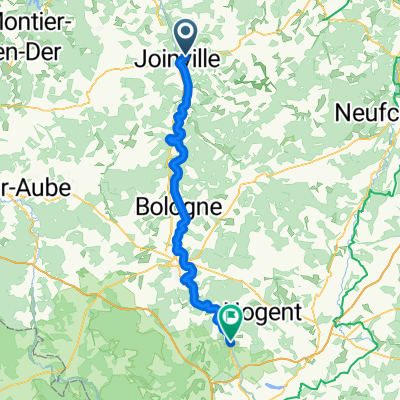
Camino 2015 5b Joinville nach Clairvaux
A cycling route starting in Joinville, Grand Est, France.
Overview
About this route
<table border="0" cellpadding="0" cellspacing="0" style="width:360px;" width="360"> <colgroup> <col /> <col /> <col /> <col /> <col span="3" /> </colgroup> <tbody> <tr height="21"> <td height="21" style="height:21px;width:34px;"> 10,5</td> <td style="width:34px;"> 10,5</td> <td colspan="2" style="width:98px;"> Donjeux</td> <td style="width:64px;"> </td> <td style="width:64px;"> </td> <td style="width:64px;"> </td> </tr> <tr height="21"> <td height="21" style="height:21px;width:34px;"> 20,0</td> <td style="width:34px;"> 9,5</td> <td colspan="5"> Les Herbues/Ende Radweg (---> D186)</td> </tr> <tr height="21"> <td height="21" style="height:21px;width:34px;"> 23,5</td> <td style="width:34px;"> 3,5</td> <td colspan="4"> Cerisieres (2km Anstieg)</td> <td> </td> </tr> <tr height="21"> <td height="21" style="height:21px;width:34px;"> 29,0</td> <td style="width:34px;"> 5,5</td> <td colspan="2"> Marbéville</td> <td> </td> <td> </td> <td> </td> </tr> <tr height="21"> <td height="21" style="height:21px;width:34px;"> 33,4</td> <td style="width:34px;"> 4,4</td> <td colspan="5"> Abzweig nach Curmont/Lamothe --> D133)</td> </tr> <tr height="21"> <td height="21" style="height:21px;width:34px;"> 35,4</td> <td style="width:34px;"> 2,0</td> <td colspan="4"> Curmont rechts liegen lassen </td> <td> </td> </tr> <tr height="21"> <td height="21" style="height:21px;width:34px;"> 37,9</td> <td style="width:34px;"> 2,5</td> <td colspan="5"> Lamothe-en-Blaisy ---> Colombey --> D235</td> </tr> <tr height="21"> <td height="21" style="height:21px;width:34px;"> 42,9</td> <td style="width:34px;"> 5,0</td> <td colspan="4"> Colombey-les-deux-eglises</td> <td> </td> </tr> <tr height="21"> <td height="21" style="height:21px;width:34px;"> 46,2</td> <td style="width:34px;"> 3,3</td> <td colspan="5"> Abzweig im Wald - braunes Schild</td> </tr> <tr height="21"> <td height="21" style="height:21px;width:34px;"> 50,0</td> <td style="width:34px;"> 3,8</td> <td colspan="2"> ---> rechts</td> <td> </td> <td> </td> <td> </td> </tr> <tr height="21"> <td height="21" style="height:21px;width:34px;"> 55,5</td> <td style="width:34px;"> 5,5</td> <td colspan="2"> Clairvaux</td> <td> </td> <td> </td> <td> </td> </tr> </tbody> </table>
nach Verlassen des Radweges bei km 20<br /> ca. 3 km Anstieg um ca. 130 hm<br /> dann 10 km hügelig abwärts,<br /> D133 sieht super aus<br /> danach 10 km hügelig bergan<br /> bei km 52 steil bergab Hôtel Restaurant de l'Abbaye<br /> 19, route de Dijon 10310 Clairvaux<br /> Telefon +33325278012- -:--
- Duration
- 55.8 km
- Distance
- 378 m
- Ascent
- 368 m
- Descent
- ---
- Avg. speed
- ---
- Max. altitude

Route quality
Waytypes & surfaces along the route
Waytypes
Road
18 km
(32 %)
Access road
14.9 km
(27 %)
Surfaces
Paved
43.7 km
(78 %)
Unpaved
0.7 km
(1 %)
Asphalt
29 km
(52 %)
Paved (undefined)
14.7 km
(26 %)
Continue with Bikemap
Use, edit, or download this cycling route
You would like to ride Camino 2015 5b Joinville nach Clairvaux or customize it for your own trip? Here is what you can do with this Bikemap route:
Free features
- Save this route as favorite or in collections
- Copy & plan your own version of this route
- Sync your route with Garmin or Wahoo
Premium features
Free trial for 3 days, or one-time payment. More about Bikemap Premium.
- Navigate this route on iOS & Android
- Export a GPX / KML file of this route
- Create your custom printout (try it for free)
- Download this route for offline navigation
Discover more Premium features.
Get Bikemap PremiumFrom our community
Other popular routes starting in Joinville
 Camino 2015 5b Joinville nach Clairvaux
- Distance
- 55.8 km
- Ascent
- 378 m
- Descent
- 368 m
- Location
- Joinville, Grand Est, France
 Taizé 20-5
- Distance
- 94.5 km
- Ascent
- 293 m
- Descent
- 38 m
- Location
- Joinville, Grand Est, France
 italy day 3
- Distance
- 218.7 km
- Ascent
- 2,474 m
- Descent
- 2,281 m
- Location
- Joinville, Grand Est, France
 Paris 8
- Distance
- 141.5 km
- Ascent
- 82 m
- Descent
- 255 m
- Location
- Joinville, Grand Est, France
 10A Echenay - Ville-sous-la-Ferté Jakobsweg
- Distance
- 69.1 km
- Ascent
- 634 m
- Descent
- 735 m
- Location
- Joinville, Grand Est, France
 Joinville - Rolampont
- Distance
- 74.3 km
- Ascent
- 387 m
- Descent
- 270 m
- Location
- Joinville, Grand Est, France
 lac 1
lac 1- Distance
- 52.4 km
- Ascent
- 747 m
- Descent
- 749 m
- Location
- Joinville, Grand Est, France
 Joinville - Epernay
- Distance
- 130.4 km
- Ascent
- 258 m
- Descent
- 373 m
- Location
- Joinville, Grand Est, France
Open it in the app