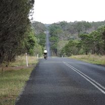
Armidale to Blue Hole
A cycling route starting in Armidale, New South Wales, Australia.
Overview
About this route
An easy ride on mostly flat tar roads, with a short hilly section at the end where the road drops down to the Gara River. Total distance 36 kms round trip.
Ride out of town on the Waterfall Way. Turn off onto Castledoyle Road. Head out to the junction with Blue Hole Road. The tar ends here with just a few short kilometres of dirt road to Blue Hole.
Great swimming spot in summer, spectacular raging river after heavy rain.
- -:--
- Duration
- 18.1 km
- Distance
- 165 m
- Ascent
- 183 m
- Descent
- ---
- Avg. speed
- 1,043 m
- Max. altitude
Route quality
Waytypes & surfaces along the route
Waytypes
Quiet road
16.7 km
(92 %)
Track
0.6 km
(4 %)
Surfaces
Paved
16.4 km
(90 %)
Unpaved
1.7 km
(10 %)
Asphalt
15.9 km
(88 %)
Unpaved (undefined)
1.1 km
(6 %)
Continue with Bikemap
Use, edit, or download this cycling route
You would like to ride Armidale to Blue Hole or customize it for your own trip? Here is what you can do with this Bikemap route:
Free features
- Save this route as favorite or in collections
- Copy & plan your own version of this route
- Sync your route with Garmin or Wahoo
Premium features
Free trial for 3 days, or one-time payment. More about Bikemap Premium.
- Navigate this route on iOS & Android
- Export a GPX / KML file of this route
- Create your custom printout (try it for free)
- Download this route for offline navigation
Discover more Premium features.
Get Bikemap PremiumFrom our community
Other popular routes starting in Armidale
 Flat White
- Distance
- 19.5 km
- Ascent
- 203 m
- Descent
- 201 m
- Location
- Armidale, New South Wales, Australia
 Armidale, Toms Gully, Puddledock loop
- Distance
- 71.6 km
- Ascent
- 607 m
- Descent
- 607 m
- Location
- Armidale, New South Wales, Australia
 New England Cycle Trail South
- Distance
- 353.4 km
- Ascent
- 999 m
- Descent
- 1,577 m
- Location
- Armidale, New South Wales, Australia
 Armidale to Point Lookout loop
- Distance
- 226.3 km
- Ascent
- 4,225 m
- Descent
- 4,225 m
- Location
- Armidale, New South Wales, Australia
 Armidale Tourist Information Centre to Dangars Gorge return
- Distance
- 47 km
- Ascent
- 355 m
- Descent
- 353 m
- Location
- Armidale, New South Wales, Australia
 Avoiding the Waterfall Way from Armidale
- Distance
- 92.5 km
- Ascent
- 708 m
- Descent
- 708 m
- Location
- Armidale, New South Wales, Australia
 Apple tree drive loop for kids
- Distance
- 7.8 km
- Ascent
- 92 m
- Descent
- 93 m
- Location
- Armidale, New South Wales, Australia
 Armidale, Rockvale Rd Chandler Rd loop
- Distance
- 86.1 km
- Ascent
- 772 m
- Descent
- 773 m
- Location
- Armidale, New South Wales, Australia
Open it in the app

