

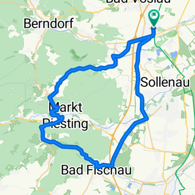
Le Tour de Norbert
A cycling route starting in Kottingbrunn, Lower Austria, Austria.
Overview
About this route
Le Tour de Norbert
- -:--
- Duration
- 143 km
- Distance
- 848 m
- Ascent
- 851 m
- Descent
- ---
- Avg. speed
- ---
- Max. altitude
Route quality
Waytypes & surfaces along the route
Waytypes
Busy road
70.1 km
(49 %)
Quiet road
27.7 km
(19 %)
Surfaces
Paved
99 km
(69 %)
Unpaved
2.1 km
(2 %)
Asphalt
93.4 km
(65 %)
Paved (undefined)
4.6 km
(3 %)
Route highlights
Points of interest along the route

Photo after 30.7 km
Hochrotherd
Continue with Bikemap
Use, edit, or download this cycling route
You would like to ride Le Tour de Norbert or customize it for your own trip? Here is what you can do with this Bikemap route:
Free features
- Save this route as favorite or in collections
- Copy & plan your own version of this route
- Split it into stages to create a multi-day tour
- Sync your route with Garmin or Wahoo
Premium features
Free trial for 3 days, or one-time payment. More about Bikemap Premium.
- Navigate this route on iOS & Android
- Export a GPX / KML file of this route
- Create your custom printout (try it for free)
- Download this route for offline navigation
Discover more Premium features.
Get Bikemap PremiumFrom our community
Other popular routes starting in Kottingbrunn
 Taurus Tour
- Distance
- 70.9 km
- Ascent
- 1,552 m
- Descent
- 1,436 m
- Location
- Kottingbrunn, Lower Austria, Austria
 berndorf mit opi
- Distance
- 13.5 km
- Ascent
- 259 m
- Descent
- 204 m
- Location
- Kottingbrunn, Lower Austria, Austria
 Radtour 2008 Schweiger
- Distance
- 104.8 km
- Ascent
- 1,296 m
- Descent
- 1,303 m
- Location
- Kottingbrunn, Lower Austria, Austria
 Südl. NÖ Abendtour
- Distance
- 44.1 km
- Ascent
- 140 m
- Descent
- 141 m
- Location
- Kottingbrunn, Lower Austria, Austria
 07.03.2015
- Distance
- 112.8 km
- Ascent
- 659 m
- Descent
- 659 m
- Location
- Kottingbrunn, Lower Austria, Austria
 Okolo Schneebergu AT opravená
- Distance
- 142 km
- Ascent
- 1,459 m
- Descent
- 1,459 m
- Location
- Kottingbrunn, Lower Austria, Austria
 Ausfahrt von Kottingbrunn nach Traiskirchen
- Distance
- 12.3 km
- Ascent
- 4 m
- Descent
- 59 m
- Location
- Kottingbrunn, Lower Austria, Austria
 Kürassier Runde
- Distance
- 43.4 km
- Ascent
- 550 m
- Descent
- 543 m
- Location
- Kottingbrunn, Lower Austria, Austria
Open it in the app