

Gradisca-Rocca-Cima Pietrarossa e single tracks monte San Michele
A cycling route starting in Sagrado, Friuli Venezia Giulia, Italy.
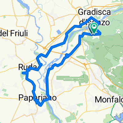
Overview
About this route
Start and finish from the car park of the Al Ponte restaurant in Gradisca. The route winds along karst trails and single tracks to reach the Rocca di Monfalcone, the World War I trenches at Cima Pietrarossa (elevation 121), then returns via Lake Doberdò through the Brestovec cannon galleries and then climbs Monte San Michele from which you descend through two very technical and challenging single tracks. The route is suitable for everyone in the first part, becoming demanding both technically and physically in the second part after reaching the Brestovec galleries.
- -:--
- Duration
- 55.4 km
- Distance
- 594 m
- Ascent
- 594 m
- Descent
- ---
- Avg. speed
- ---
- Max. altitude
Route quality
Waytypes & surfaces along the route
Waytypes
Track
33.2 km
(60 %)
Quiet road
9.4 km
(17 %)
Surfaces
Paved
5 km
(9 %)
Unpaved
34.3 km
(62 %)
Gravel
31.6 km
(57 %)
Asphalt
4.4 km
(8 %)
Continue with Bikemap
Use, edit, or download this cycling route
You would like to ride Gradisca-Rocca-Cima Pietrarossa e single tracks monte San Michele or customize it for your own trip? Here is what you can do with this Bikemap route:
Free features
- Save this route as favorite or in collections
- Copy & plan your own version of this route
- Sync your route with Garmin or Wahoo
Premium features
Free trial for 3 days, or one-time payment. More about Bikemap Premium.
- Navigate this route on iOS & Android
- Export a GPX / KML file of this route
- Create your custom printout (try it for free)
- Download this route for offline navigation
Discover more Premium features.
Get Bikemap PremiumFrom our community
Other popular routes starting in Sagrado
 SAGRADO-GRADO 2020
- Distance
- 43.6 km
- Ascent
- 0 m
- Descent
- 20 m
- Location
- Sagrado, Friuli Venezia Giulia, Italy
 trincee italia-slovenia
- Distance
- 33.8 km
- Ascent
- 475 m
- Descent
- 564 m
- Location
- Sagrado, Friuli Venezia Giulia, Italy
 Sagrado Stiak - Stanjel Gorianko
- Distance
- 107.5 km
- Ascent
- 850 m
- Descent
- 851 m
- Location
- Sagrado, Friuli Venezia Giulia, Italy
 Gradisca-Palmanova-Udine-Gradisca
- Distance
- 82.9 km
- Ascent
- 214 m
- Descent
- 216 m
- Location
- Sagrado, Friuli Venezia Giulia, Italy
 Giro del sabato
- Distance
- 55.1 km
- Ascent
- 137 m
- Descent
- 136 m
- Location
- Sagrado, Friuli Venezia Giulia, Italy
 Korada
- Distance
- 82.5 km
- Ascent
- 751 m
- Descent
- 752 m
- Location
- Sagrado, Friuli Venezia Giulia, Italy
 Da Località Castelnuovo a Località Castelnuovo
- Distance
- 36.7 km
- Ascent
- 153 m
- Descent
- 152 m
- Location
- Sagrado, Friuli Venezia Giulia, Italy
 Sagrado- Goriansko
- Distance
- 50.3 km
- Ascent
- 542 m
- Descent
- 545 m
- Location
- Sagrado, Friuli Venezia Giulia, Italy
Open it in the app