

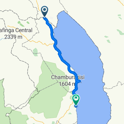
MW_Karonga-Mlowe
A cycling route starting in Kyela, Mbeya, Tanzania.
Overview
About this route
Zum Malawisee. Von der tansanischen Grenze bis nach Mlowe
- -:--
- Duration
- 169.4 km
- Distance
- 345 m
- Ascent
- 347 m
- Descent
- ---
- Avg. speed
- ---
- Max. altitude
Continue with Bikemap
Use, edit, or download this cycling route
You would like to ride MW_Karonga-Mlowe or customize it for your own trip? Here is what you can do with this Bikemap route:
Free features
- Save this route as favorite or in collections
- Copy & plan your own version of this route
- Split it into stages to create a multi-day tour
- Sync your route with Garmin or Wahoo
Premium features
Free trial for 3 days, or one-time payment. More about Bikemap Premium.
- Navigate this route on iOS & Android
- Export a GPX / KML file of this route
- Create your custom printout (try it for free)
- Download this route for offline navigation
Discover more Premium features.
Get Bikemap PremiumFrom our community
Other popular routes starting in Kyela
 MW_Karonga-Mlowe
- Distance
- 169.4 km
- Ascent
- 345 m
- Descent
- 347 m
- Location
- Kyela, Mbeya, Tanzania
 馬拉威與莫三比克(Malawi and Mozambique)
- Distance
- 1,720.2 km
- Ascent
- 4,037 m
- Descent
- 3,454 m
- Location
- Kyela, Mbeya, Tanzania
 Tukuyu to Lusaka first
- Distance
- 1,358.7 km
- Ascent
- 3,276 m
- Descent
- 2,498 m
- Location
- Kyela, Mbeya, Tanzania
 Bottom to Eritrea
- Distance
- 5,278.6 km
- Ascent
- 42,493 m
- Descent
- 40,647 m
- Location
- Kyela, Mbeya, Tanzania
 Tanzani 17j(13b-4v)
- Distance
- 1,258.6 km
- Ascent
- 4,763 m
- Descent
- 3,944 m
- Location
- Kyela, Mbeya, Tanzania
 Kyela nach Lusaka südlich
- Distance
- 1,324.6 km
- Ascent
- 3,648 m
- Descent
- 2,871 m
- Location
- Kyela, Mbeya, Tanzania
Open it in the app