

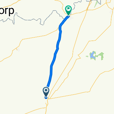
Long Safe Route in Kroonstad
A cycling route starting in Kroonstad, Free State, Republic of South Africa.
Overview
About this route
Longest safe route that borders the downtown of Kroonstad. By sticking to this route, your chances of getting hurt by crimials are greatly deminished.
- -:--
- Duration
- 9.7 km
- Distance
- 32 m
- Ascent
- 33 m
- Descent
- ---
- Avg. speed
- ---
- Max. altitude
Route quality
Waytypes & surfaces along the route
Waytypes
Quiet road
9.6 km
(99 %)
Undefined
0.1 km
(1 %)
Surfaces
Paved
8.8 km
(91 %)
Asphalt
8.8 km
(91 %)
Undefined
0.9 km
(9 %)
Continue with Bikemap
Use, edit, or download this cycling route
You would like to ride Long Safe Route in Kroonstad or customize it for your own trip? Here is what you can do with this Bikemap route:
Free features
- Save this route as favorite or in collections
- Copy & plan your own version of this route
- Sync your route with Garmin or Wahoo
Premium features
Free trial for 3 days, or one-time payment. More about Bikemap Premium.
- Navigate this route on iOS & Android
- Export a GPX / KML file of this route
- Create your custom printout (try it for free)
- Download this route for offline navigation
Discover more Premium features.
Get Bikemap PremiumFrom our community
Other popular routes starting in Kroonstad
 21 Kommando Crescent, Kroonstad to 5 Kleinschmidt Street, Kroonstad
- Distance
- 34 km
- Ascent
- 1,299 m
- Descent
- 1,300 m
- Location
- Kroonstad, Free State, Republic of South Africa
 Day 1 Kroonstad to Parys
- Distance
- 85.3 km
- Ascent
- 317 m
- Descent
- 363 m
- Location
- Kroonstad, Free State, Republic of South Africa
 Long Safe Route in Kroonstad
- Distance
- 9.7 km
- Ascent
- 32 m
- Descent
- 33 m
- Location
- Kroonstad, Free State, Republic of South Africa
Open it in the app