
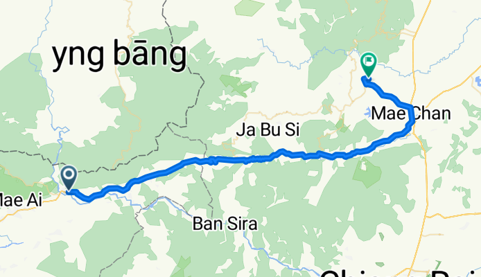
Chiang_Mai_Day3
A cycling route starting in Mae Ai, Chiang Mai, Thailand.
Overview
About this route
- -:--
- Duration
- 72.5 km
- Distance
- 579 m
- Ascent
- 554 m
- Descent
- ---
- Avg. speed
- ---
- Max. altitude
Route quality
Waytypes & surfaces along the route
Waytypes
Quiet road
14.5 km
(20 %)
Access road
0.7 km
(1 %)
Surfaces
Paved
50.1 km
(69 %)
Unpaved
0.7 km
(1 %)
Asphalt
50.1 km
(69 %)
Unpaved (undefined)
0.7 km
(1 %)
Undefined
21.8 km
(30 %)
Continue with Bikemap
Use, edit, or download this cycling route
You would like to ride Chiang_Mai_Day3 or customize it for your own trip? Here is what you can do with this Bikemap route:
Free features
- Save this route as favorite or in collections
- Copy & plan your own version of this route
- Sync your route with Garmin or Wahoo
Premium features
Free trial for 3 days, or one-time payment. More about Bikemap Premium.
- Navigate this route on iOS & Android
- Export a GPX / KML file of this route
- Create your custom printout (try it for free)
- Download this route for offline navigation
Discover more Premium features.
Get Bikemap PremiumFrom our community
Other popular routes starting in Mae Ai
 tha ton to chiang rai on river
- Distance
- 71.8 km
- Ascent
- 422 m
- Descent
- 473 m
- Location
- Mae Ai, Chiang Mai, Thailand
 Mae Ai - Mae Salong
- Distance
- 60.6 km
- Ascent
- 1,245 m
- Descent
- 603 m
- Location
- Mae Ai, Chiang Mai, Thailand
 Tha ton to chiang rai through Wawi
- Distance
- 85 km
- Ascent
- 1,807 m
- Descent
- 1,855 m
- Location
- Mae Ai, Chiang Mai, Thailand
 Fang Hot Spring national park von Maekok
- Distance
- 32.8 km
- Ascent
- 176 m
- Descent
- 108 m
- Location
- Mae Ai, Chiang Mai, Thailand
 Tha Ton - Chiang Khong - Final 1
- Distance
- 147.7 km
- Ascent
- 903 m
- Descent
- 993 m
- Location
- Mae Ai, Chiang Mai, Thailand
 Tha Ton to Chiang Dao
- Distance
- 130.7 km
- Ascent
- 671 m
- Descent
- 731 m
- Location
- Mae Ai, Chiang Mai, Thailand
 chiang dao np
- Distance
- 121.4 km
- Ascent
- 1,798 m
- Descent
- 1,665 m
- Location
- Mae Ai, Chiang Mai, Thailand
 Tha Ton to Mae Salong, Thailand
- Distance
- 45.1 km
- Ascent
- 1,257 m
- Descent
- 576 m
- Location
- Mae Ai, Chiang Mai, Thailand
Open it in the app