

Palenčáreň 2015 "krátka"
A cycling route starting in Gelnica, Košice Region, Slovakia.
Overview
About this route
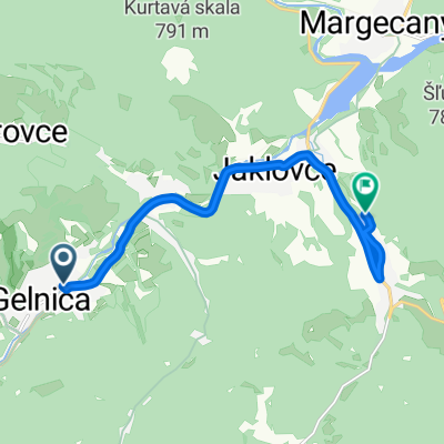
Proposal for a 'short' (but not easy) route. From Palenčáreň down the hill through Gelnica, on the main road to Jaklovce, in Jaklovce left towards Margecany. At the end of the fence of the lime plant, turn left, up the ramp. The climb to Kurtová skala begins (about 350 vertical meters), as a reward there will be a wonderful view from the extraction platform. Behind Kurtová skala, the route continues through the forest and meadows towards Bačov vrch and Plejsy. In the meadows above Žakarovce, beautiful views will appear again: to the right Sľubica, to the left Folkmárska skal, Kojšovka... Here a small detour to Plejsy is possible (depending on the mood). From Plesov (junction), the route along a beautiful old mining road (green TZ) bypasses Krompašský vrch towards the Tatarkov cross, but does not go down to the cross, turns left on descent onto a wider forest road towards Gáborka (cabin). The Gáborka hut is bypassed to the left, behind the hut it turns right and continues along the ridge, first gently, then steeply down to gelnické Stonehenge :o) Here the route turns right and returns to Palenčáreň through the meadows above Gelnica (either directly down the hill or with a small detour through Slovak guilds).
- -:--
- Duration
- 31.9 km
- Distance
- 787 m
- Ascent
- 787 m
- Descent
- ---
- Avg. speed
- ---
- Max. altitude
Route highlights
Points of interest along the route
Point of interest after 17.8 km
výhľad: napravo Branisko, Sľubica, naľavo Folkmárska skala, Kojšovka
Point of interest after 29 km
voľba trasy: doľava dole kopcom priamo k Palenčárni, alebo rovno na Slovenské cechy. Odporúčam rovno :o)
Continue with Bikemap
Use, edit, or download this cycling route
You would like to ride Palenčáreň 2015 "krátka" or customize it for your own trip? Here is what you can do with this Bikemap route:
Free features
- Save this route as favorite or in collections
- Copy & plan your own version of this route
- Sync your route with Garmin or Wahoo
Premium features
Free trial for 3 days, or one-time payment. More about Bikemap Premium.
- Navigate this route on iOS & Android
- Export a GPX / KML file of this route
- Create your custom printout (try it for free)
- Download this route for offline navigation
Discover more Premium features.
Get Bikemap PremiumFrom our community
Other popular routes starting in Gelnica
 Mníšek nad Hnilcom-Úhorná-Úhornianske sedlo-sedlo medzi Bielimi Skalami a Hekerovou- Stará Voda- Mníšek nad Hnilcom
- Distance
- 47.8 km
- Ascent
- 982 m
- Descent
- 974 m
- Location
- Gelnica, Košice Region, Slovakia
 Palenčáreň 2015 "dlhá"
- Distance
- 63.4 km
- Ascent
- 1,425 m
- Descent
- 1,425 m
- Location
- Gelnica, Košice Region, Slovakia
 Okolo Ružína
- Distance
- 44.7 km
- Ascent
- 948 m
- Descent
- 953 m
- Location
- Gelnica, Košice Region, Slovakia
 Tatarkov kríž-Gáborka-Slovenské cechy-Thurzov jazero
- Distance
- 5.2 km
- Ascent
- 97 m
- Descent
- 460 m
- Location
- Gelnica, Košice Region, Slovakia
 Gelnica- Jaklovce- V. Folkmar- v.n. Jaklovce
- Distance
- 8.9 km
- Ascent
- 117 m
- Descent
- 106 m
- Location
- Gelnica, Košice Region, Slovakia
 Prakovce- Polianka- Prakovce
- Distance
- 17.1 km
- Ascent
- 634 m
- Descent
- 634 m
- Location
- Gelnica, Košice Region, Slovakia
 My favorite
- Distance
- 16 km
- Ascent
- 808 m
- Descent
- 803 m
- Location
- Gelnica, Košice Region, Slovakia
 Gelnica - chata Diana - Tatarkov kríž
- Distance
- 8 km
- Ascent
- 670 m
- Descent
- 158 m
- Location
- Gelnica, Košice Region, Slovakia
Open it in the app