

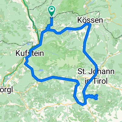
Buchberg-Ebbs mountain road
A cycling route starting in Rettenschöss, Tyrol, Austria.
Overview
About this route
mostly downhill on a paved, narrow public road
- -:--
- Duration
- 5.6 km
- Distance
- 40 m
- Ascent
- 216 m
- Descent
- ---
- Avg. speed
- ---
- Max. altitude

Route quality
Waytypes & surfaces along the route
Waytypes
Quiet road
3.9 km
(71 %)
Road
1.4 km
(26 %)
Access road
0.2 km
(3 %)
Surfaces
Paved
5.4 km
(97 %)
Asphalt
5.4 km
(97 %)
Undefined
0.2 km
(3 %)
Continue with Bikemap
Use, edit, or download this cycling route
You would like to ride Buchberg-Ebbs mountain road or customize it for your own trip? Here is what you can do with this Bikemap route:
Free features
- Save this route as favorite or in collections
- Copy & plan your own version of this route
- Sync your route with Garmin or Wahoo
Premium features
Free trial for 3 days, or one-time payment. More about Bikemap Premium.
- Navigate this route on iOS & Android
- Export a GPX / KML file of this route
- Create your custom printout (try it for free)
- Download this route for offline navigation
Discover more Premium features.
Get Bikemap PremiumFrom our community
Other popular routes starting in Rettenschöss
 Burgeralm/Käserei
- Distance
- 9.4 km
- Ascent
- 455 m
- Descent
- 458 m
- Location
- Rettenschöss, Tyrol, Austria
 Buchberg-Ebbs mountain road
- Distance
- 5.6 km
- Ascent
- 40 m
- Descent
- 216 m
- Location
- Rettenschöss, Tyrol, Austria
 RR-RO-Durchholzen via Erlberg-46km
- Distance
- 45.9 km
- Ascent
- 544 m
- Descent
- 790 m
- Location
- Rettenschöss, Tyrol, Austria
 Kitzbühler Horn
- Distance
- 121.7 km
- Ascent
- 2,159 m
- Descent
- 2,159 m
- Location
- Rettenschöss, Tyrol, Austria
 Niederdorf to Kitzbuhel
- Distance
- 46 km
- Ascent
- 287 m
- Descent
- 203 m
- Location
- Rettenschöss, Tyrol, Austria
 Schiesseralm Trail / Frani Haustrail
- Distance
- 12.9 km
- Ascent
- 595 m
- Descent
- 597 m
- Location
- Rettenschöss, Tyrol, Austria
 ride from Rettenschöss to Walchsee
- Distance
- 14.2 km
- Ascent
- 205 m
- Descent
- 546 m
- Location
- Rettenschöss, Tyrol, Austria
 Buchberg - Walchsee
- Distance
- 31.7 km
- Ascent
- 355 m
- Descent
- 350 m
- Location
- Rettenschöss, Tyrol, Austria
Open it in the app