

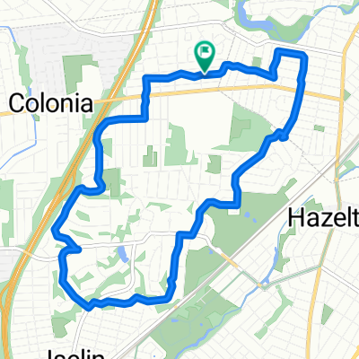
Bike Route
A cycling route starting in Rahway, New Jersey, United States.
Overview
About this route
union county performing art center merchants and drovers tavern Dr. william robinson plantation
- -:--
- Duration
- 9.9 km
- Distance
- 35 m
- Ascent
- 34 m
- Descent
- ---
- Avg. speed
- ---
- Max. altitude
Route quality
Waytypes & surfaces along the route
Waytypes
Quiet road
5 km
(50 %)
Cycleway
2.4 km
(24 %)
Surfaces
Paved
2.3 km
(23 %)
Asphalt
2.2 km
(22 %)
Concrete
0.1 km
(1 %)
Undefined
7.6 km
(77 %)
Route highlights
Points of interest along the route
Point of interest after 1.7 km
Dr. William Roberson Plantation 593 Madison Hill Road, Clark
Point of interest after 4.3 km
Merchants and Dovers tavern 1632 St. George Road, Rahway
Point of interest after 6.7 km
union county performing arts center 1601 Irving Street , Rahway
Continue with Bikemap
Use, edit, or download this cycling route
You would like to ride Bike Route or customize it for your own trip? Here is what you can do with this Bikemap route:
Free features
- Save this route as favorite or in collections
- Copy & plan your own version of this route
- Sync your route with Garmin or Wahoo
Premium features
Free trial for 3 days, or one-time payment. More about Bikemap Premium.
- Navigate this route on iOS & Android
- Export a GPX / KML file of this route
- Create your custom printout (try it for free)
- Download this route for offline navigation
Discover more Premium features.
Get Bikemap PremiumFrom our community
Other popular routes starting in Rahway
 Ride through Colonia/Rahway
- Distance
- 9.8 km
- Ascent
- 61 m
- Descent
- 61 m
- Location
- Rahway, New Jersey, United States
 Quick ride through Woodbridge Township
- Distance
- 9.9 km
- Ascent
- 62 m
- Descent
- 63 m
- Location
- Rahway, New Jersey, United States
 Bike Route
- Distance
- 9.9 km
- Ascent
- 35 m
- Descent
- 34 m
- Location
- Rahway, New Jersey, United States
 Route to Barnett Street 1955, Rahway
- Distance
- 30.1 km
- Ascent
- 29 m
- Descent
- 30 m
- Location
- Rahway, New Jersey, United States
 East Milton Avenue 734, Rahway to Barnett Street 1955, Rahway
- Distance
- 25.7 km
- Ascent
- 37 m
- Descent
- 39 m
- Location
- Rahway, New Jersey, United States
 Barnett Street 1946, Rahway to Barnett Street 1949, Rahway
- Distance
- 31 km
- Ascent
- 104 m
- Descent
- 67 m
- Location
- Rahway, New Jersey, United States
 Stone Street 1191, Rahway to Wilsey Street 42, Newark
- Distance
- 19.4 km
- Ascent
- 80 m
- Descent
- 62 m
- Location
- Rahway, New Jersey, United States
 De Saint Georges Avenue 1843-1967, Rahway a East Saint Georges Avenue 1842, Linden
- Distance
- 11.3 km
- Ascent
- 34 m
- Descent
- 37 m
- Location
- Rahway, New Jersey, United States
Open it in the app