

Römeretappe
A cycling route starting in Marpingen, Saarland, Germany.
Overview
About this route
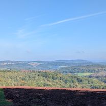
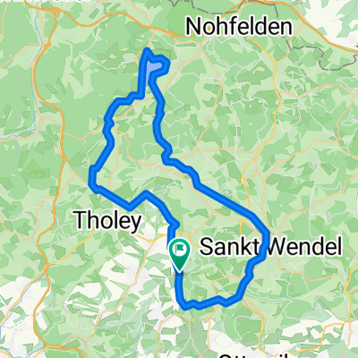
From Marpingen via Rheinstraße to Tholey, then through Theley to Gronig. Then over Kapelenwiese, Nohmühle to Bostalsee, passing Neunkirchen Nahe, Selbach, and returning to Marpingen. A very nice route. At an average speed, one should take about 4 hours to also enjoy the beauty of the St. Wendel area.
- -:--
- Duration
- 47.1 km
- Distance
- 620 m
- Ascent
- 623 m
- Descent
- ---
- Avg. speed
- ---
- Max. altitude
Continue with Bikemap
Use, edit, or download this cycling route
You would like to ride Römeretappe or customize it for your own trip? Here is what you can do with this Bikemap route:
Free features
- Save this route as favorite or in collections
- Copy & plan your own version of this route
- Sync your route with Garmin or Wahoo
Premium features
Free trial for 3 days, or one-time payment. More about Bikemap Premium.
- Navigate this route on iOS & Android
- Export a GPX / KML file of this route
- Create your custom printout (try it for free)
- Download this route for offline navigation
Discover more Premium features.
Get Bikemap PremiumFrom our community
Other popular routes starting in Marpingen
 Rundweg Marpinger Land
- Distance
- 16.7 km
- Ascent
- 251 m
- Descent
- 251 m
- Location
- Marpingen, Saarland, Germany
 Friedrichstraße nach Am Langenstrank
- Distance
- 40.6 km
- Ascent
- 510 m
- Descent
- 557 m
- Location
- Marpingen, Saarland, Germany
 Marpingen - Skulpturenstraße - Bostalsee
- Distance
- 54.7 km
- Ascent
- 602 m
- Descent
- 617 m
- Location
- Marpingen, Saarland, Germany
 Römeretappe
- Distance
- 47.1 km
- Ascent
- 620 m
- Descent
- 623 m
- Location
- Marpingen, Saarland, Germany
 MTB 5 Sankt Wendeler Land
- Distance
- 21.1 km
- Ascent
- 339 m
- Descent
- 339 m
- Location
- Marpingen, Saarland, Germany
 Wünschberg Tour
- Distance
- 41.7 km
- Ascent
- 533 m
- Descent
- 533 m
- Location
- Marpingen, Saarland, Germany
 Sankt Wendeler Land 1
- Distance
- 48.6 km
- Ascent
- 475 m
- Descent
- 497 m
- Location
- Marpingen, Saarland, Germany
 Am Langenstrank nach Am Langenstrank
- Distance
- 38.9 km
- Ascent
- 560 m
- Descent
- 604 m
- Location
- Marpingen, Saarland, Germany
Open it in the app