

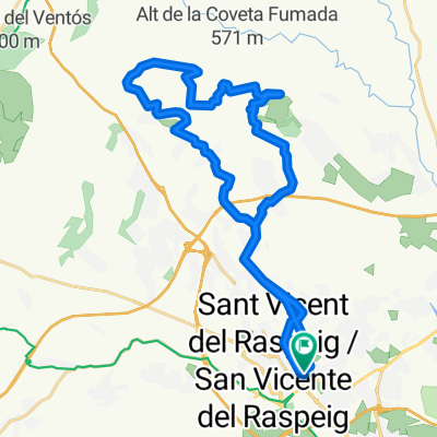
Llegada Marcha Cicloturista Ciudad de San Vicente
A cycling route starting in San Vicent del Raspeig, Valencia, Spain.
Overview
About this route
Arrival of the Ciudad de San Vicente Cycling Tour
- -:--
- Duration
- 3.9 km
- Distance
- 10 m
- Ascent
- 60 m
- Descent
- ---
- Avg. speed
- ---
- Max. altitude

Route quality
Waytypes & surfaces along the route
Waytypes
Access road
0.8 km
(20 %)
Undefined
3.1 km
(80 %)
Surfaces
Paved
0.4 km
(10 %)
Asphalt
0.4 km
(10 %)
Undefined
3.5 km
(90 %)
Continue with Bikemap
Use, edit, or download this cycling route
You would like to ride Llegada Marcha Cicloturista Ciudad de San Vicente or customize it for your own trip? Here is what you can do with this Bikemap route:
Free features
- Save this route as favorite or in collections
- Copy & plan your own version of this route
- Sync your route with Garmin or Wahoo
Premium features
Free trial for 3 days, or one-time payment. More about Bikemap Premium.
- Navigate this route on iOS & Android
- Export a GPX / KML file of this route
- Create your custom printout (try it for free)
- Download this route for offline navigation
Discover more Premium features.
Get Bikemap PremiumFrom our community
Other popular routes starting in San Vicent del Raspeig
 San Vicente-Campello-Aguas-Pantano Amadorio-Orxeta-Finestrat-Villajoyosa-Orxeta-Relleu-Aguas-Busot-Muchamiel-San Vicente
- Distance
- 111.5 km
- Ascent
- 1,123 m
- Descent
- 1,122 m
- Location
- San Vicent del Raspeig, Valencia, Spain
 alicante geiser
- Distance
- 32.5 km
- Ascent
- 621 m
- Descent
- 596 m
- Location
- San Vicent del Raspeig, Valencia, Spain
 RUTA SAN VICENTE-SABINAR-MONEGRE-SAN VICENTE
- Distance
- 31.4 km
- Ascent
- 459 m
- Descent
- 458 m
- Location
- San Vicent del Raspeig, Valencia, Spain
 (1.880m) SAN VICENTE-AGOST-TIBI-XIXONA-TORREMANZANAS-RELLEU-AIGÜES-BUSOT-CAMPELLO-SAN VICENTE
- Distance
- 120.1 km
- Ascent
- 2,603 m
- Descent
- 2,544 m
- Location
- San Vicent del Raspeig, Valencia, Spain
 Llegada Marcha Cicloturista Ciudad de San Vicente
- Distance
- 3.9 km
- Ascent
- 10 m
- Descent
- 60 m
- Location
- San Vicent del Raspeig, Valencia, Spain
 ALICANTE-TUDONS-ALICANTE
- Distance
- 124.2 km
- Ascent
- 1,741 m
- Descent
- 1,741 m
- Location
- San Vicent del Raspeig, Valencia, Spain
 del canal
- Distance
- 20.8 km
- Ascent
- 129 m
- Descent
- 129 m
- Location
- San Vicent del Raspeig, Valencia, Spain
 Ruta Marcha TREK Christmas Classic 2012 - San Vicente del Raspeig
- Distance
- 33.8 km
- Ascent
- 591 m
- Descent
- 589 m
- Location
- San Vicent del Raspeig, Valencia, Spain
Open it in the app