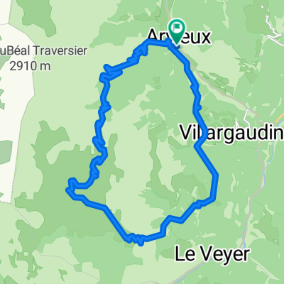
018 - 2014
- 77.7 km
- 1,637 m
- 2,039 m
- Guillestre, Provence-Alpes-Côte d'Azur Region, France
A cycling route starting in Guillestre, Provence-Alpes-Côte d'Azur Region, France.
Overview
Gigantically beautiful tour:
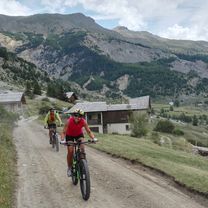
At the start, you head from the central parking lot in Arvieux (1570m) along a very nice gravel road, first through the forest and later over alpine meadows up to the Col de Furfande (2407m). The last 100-200 meters of elevation gain are really very, very tough.
Behind the Col, which offers a heavenly view, the trail continues down a great alpine meadow path initially to the Refuge de Furfande. This refuge, which is always staffed during the summer months, is beautifully situated on a slope on a plateau with views to the west.
The already beautiful trail then — almost hard to imagine — gets even more beautiful, because it becomes more exposed, with increasingly stunning viewpoints of the mountains, and later on it also becomes steeper and more demanding.
In the later part, the trail goes back through the forest to Arvieux and continues to descend steadily. The riding experience on this part of the tour can best be described as a 'gentle roller coaster': it goes slowly up and down, right and left down the slope. We rode the route very comfortably and slowly. But you can also really push it, though you should be careful not to fly over a root in an endorphin rush.
Have fun on this super tour
created this 16 years ago
Route highlights


Continue with Bikemap
You would like to ride Tour de Furfande or customize it for your own trip? Here is what you can do with this Bikemap route:
Free trial for 3 days, or one-time payment. More about Bikemap Premium.
Discover more Premium features.
Get Bikemap PremiumFrom our community
Open it in the app