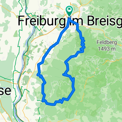
Freiburg-Weinbergerunde
A cycling route starting in Umkirch, Baden-Wurttemberg, Germany.
Overview
About this route
Mundenhof - Umkirch - March - Gottenheim - over the Tuniberg - Munzingen - Offnadingen - Kirchhofen - over the Batzenberg - Schallstadt - Opfingen - Waltershofen - Opfinger Lake - Mundenhof
The route primarily runs on paths used for agricultural or forestry purposes, rarely is a road used!
- -:--
 - Duration
 - 53.9 km
 - Distance
 - 273 m
 - Ascent
 - 276 m
 - Descent
 - ---
 - Avg. speed
 - ---
 - Max. altitude
 
Route quality
Waytypes & surfaces along the route
Waytypes
Quiet road
26.4 km
(49 %)
Track
23.2 km
(43 %)
Surfaces
Paved
42.1 km
(78 %)
Unpaved
9.7 km
(18 %)
Asphalt
34.5 km
(64 %)
Paved (undefined)
7.5 km
(14 %)
Continue with Bikemap
Use, edit, or download this cycling route
You would like to ride Freiburg-Weinbergerunde or customize it for your own trip? Here is what you can do with this Bikemap route:
Free features
- Save this route as favorite or in collections
 - Copy & plan your own version of this route
 - Sync your route with Garmin or Wahoo
 
Premium features
Free trial for 3 days, or one-time payment. More about Bikemap Premium.
- Navigate this route on iOS & Android
 - Export a GPX / KML file of this route
 - Create your custom printout (try it for free)
 - Download this route for offline navigation
 
Discover more Premium features.
Get Bikemap PremiumFrom our community
Other popular routes starting in Umkirch
Freiburg-Weinbergerunde- Distance
 - 53.9 km
 - Ascent
 - 273 m
 - Descent
 - 276 m
 - Location
 - Umkirch, Baden-Wurttemberg, Germany
 
Bötzingen Schwimmbad- Distance
 - 20.1 km
 - Ascent
 - 54 m
 - Descent
 - 53 m
 - Location
 - Umkirch, Baden-Wurttemberg, Germany
 
Frbg-Kaiserstuhlrunde-Frbg- Distance
 - 76.1 km
 - Ascent
 - 220 m
 - Descent
 - 218 m
 - Location
 - Umkirch, Baden-Wurttemberg, Germany
 
Frbg-VogelsangPass-Elsass-Breisach-Frbg- Distance
 - 76.8 km
 - Ascent
 - 328 m
 - Descent
 - 328 m
 - Location
 - Umkirch, Baden-Wurttemberg, Germany
 
Dez 17122012- Distance
 - 34 km
 - Ascent
 - 141 m
 - Descent
 - 144 m
 - Location
 - Umkirch, Baden-Wurttemberg, Germany
 
March - Dreisamtal - St. Peter - Glottertal - March- Distance
 - 53.9 km
 - Ascent
 - 560 m
 - Descent
 - 558 m
 - Location
 - Umkirch, Baden-Wurttemberg, Germany
 
Buchheim Breisach Munzingen und zurück- Distance
 - 45.6 km
 - Ascent
 - 57 m
 - Descent
 - 53 m
 - Location
 - Umkirch, Baden-Wurttemberg, Germany
 
Umkirch über Breisach ,den Kaiserstuhl und zurück- Distance
 - 66 km
 - Ascent
 - 469 m
 - Descent
 - 480 m
 - Location
 - Umkirch, Baden-Wurttemberg, Germany
 
Open it in the app


