

Cap d´Ail
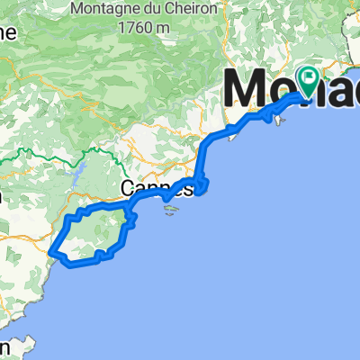
A cycling route starting in Fontvieille, Municipality of Monaco, Monaco.
Overview
About this route
<table style="width: 425pt; border-collapse: collapse;" border="0" cellspacing="0" cellpadding="0" width="567"> <tbody> <tr style="height: 14.25pt;" height="19"> <td class="xl26" style="width: 425pt; height: 14.25pt; background-color: transparent; border: windowtext 0.5pt solid;" width="567" height="19"><span style="font-size: x-small; font-family: Arial;">cap d ail-monaco-menton-ventim-san remo-arma di taggia-molini di triora-col langan-pigna-ventim-menton-monaco-cap dail</span></td> </tr> </tbody> </table>
- -:--
- Duration
- 150.9 km
- Distance
- 4,022 m
- Ascent
- 4,042 m
- Descent
- ---
- Avg. speed
- 1,147 m
- Max. altitude

Route quality
Waytypes & surfaces along the route
Waytypes
Busy road
117.3 km
(78 %)
Quiet road
13.7 km
(9 %)
Surfaces
Paved
115.2 km
(76 %)
Unpaved
1 km
(<1 %)
Asphalt
114.8 km
(76 %)
Ground
1 km
(<1 %)
Continue with Bikemap
Use, edit, or download this cycling route
You would like to ride Cap d´Ail or customize it for your own trip? Here is what you can do with this Bikemap route:
Free features
- Save this route as favorite or in collections
- Copy & plan your own version of this route
- Split it into stages to create a multi-day tour
- Sync your route with Garmin or Wahoo
Premium features
Free trial for 3 days, or one-time payment. More about Bikemap Premium.
- Navigate this route on iOS & Android
- Export a GPX / KML file of this route
- Create your custom printout (try it for free)
- Download this route for offline navigation
Discover more Premium features.
Get Bikemap PremiumFrom our community
Other popular routes starting in Fontvieille
 Cap d`Ail- Frèjus
- Distance
- 191.2 km
- Ascent
- 2,518 m
- Descent
- 2,563 m
- Location
- Fontvieille, Municipality of Monaco, Monaco
 CapFerrat-Cannes-SaintRaphael
- Distance
- 87.2 km
- Ascent
- 262 m
- Descent
- 257 m
- Location
- Fontvieille, Municipality of Monaco, Monaco
 Itinéraire vers Quai Papacino, Nice
- Distance
- 10.3 km
- Ascent
- 6 m
- Descent
- 6 m
- Location
- Fontvieille, Municipality of Monaco, Monaco
 cap ferrat bike I
- Distance
- 71.2 km
- Ascent
- 257 m
- Descent
- 257 m
- Location
- Fontvieille, Municipality of Monaco, Monaco
 le Col d'Eze depuis Cap d'Ail
- Distance
- 8.5 km
- Ascent
- 773 m
- Descent
- 332 m
- Location
- Fontvieille, Municipality of Monaco, Monaco
 Cols de la Madone et d'Eze, via Peille
- Distance
- 69.9 km
- Ascent
- 3,072 m
- Descent
- 2,881 m
- Location
- Fontvieille, Municipality of Monaco, Monaco
 Day 3
Day 3- Distance
- 34.8 km
- Ascent
- 1,101 m
- Descent
- 1,184 m
- Location
- Fontvieille, Municipality of Monaco, Monaco
 Monaco - Col de Turini
- Distance
- 53.6 km
- Ascent
- 2,082 m
- Descent
- 498 m
- Location
- Fontvieille, Municipality of Monaco, Monaco
Open it in the app