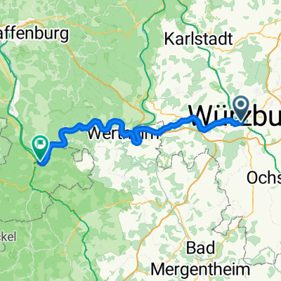
Würzburg-Aschaffenburg, Mainradweg
- 131.2 km
- 328 m
- 406 m
- Höchberg, Bavaria, Germany
A cycling route starting in Höchberg, Bavaria, Germany.
Overview
to Schwanberg via Randersacker - Westheim - Kaltensondheim - Kitzingen - Rödelsee - Iphofen - Willanzheim - Marktbreit - Ochsenfurt - Randersacker - to the fire station - 82.00 km / 1256 m of elevation gain
created this 10 years ago
Route quality
Quiet road
21.1 km
(26 %)
Path
16.3 km
(20 %)
Paved
63.4 km
(78 %)
Unpaved
0.8 km
(1 %)
Asphalt
62.6 km
(77 %)
Concrete
0.8 km
(1 %)
Route highlights
Der Schwanberg (bis ins 19. Jahrhundert auch Schwabenberg[1] oder Schwam(m)berg[2]) ist eine markante Erhebung (474 Meter) des Steigerwalds im bayerischen Regierungsbezirk Unterfranken. Bekannt ist der Berg vor allem durch seine exponierte Lage, das weithin sichtbare Schloss mit der dazugehörigen Parkanlage, die evangelische Schwesterngemeinschaft Communität Casteller Ring (CCR) mit ihrer Ordenskirche St. Michael und ihrem Ordenshaus, sowie das damit verbundene Geistliche Zentrum Schwanberg.
Continue with Bikemap
You would like to ride Schwanberg or customize it for your own trip? Here is what you can do with this Bikemap route:
Free trial for 3 days, or one-time payment. More about Bikemap Premium.
Discover more Premium features.
Get Bikemap PremiumFrom our community
Open it in the app