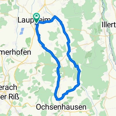
mtb - Runde Laupheim - Staig - Dellmens. - Laupheim
A cycling route starting in Laupheim, Baden-Württemberg, Germany.
Overview
About this route
None (cloned from route 1121516)
- -:--
- Duration
- 42.6 km
- Distance
- 284 m
- Ascent
- 281 m
- Descent
- ---
- Avg. speed
- ---
- Avg. speed
Route quality
Waytypes & surfaces along the route
Waytypes
Track
20.1 km
(47 %)
Quiet road
9.7 km
(23 %)
Surfaces
Paved
26 km
(61 %)
Unpaved
12.3 km
(29 %)
Asphalt
24.3 km
(57 %)
Gravel
7.9 km
(19 %)
Continue with Bikemap
Use, edit, or download this cycling route
You would like to ride mtb - Runde Laupheim - Staig - Dellmens. - Laupheim or customize it for your own trip? Here is what you can do with this Bikemap route:
Free features
- Save this route as favorite or in collections
- Copy & plan your own version of this route
- Sync your route with Garmin or Wahoo
Premium features
Free trial for 3 days, or one-time payment. More about Bikemap Premium.
- Navigate this route on iOS & Android
- Export a GPX / KML file of this route
- Create your custom printout (try it for free)
- Download this route for offline navigation
Discover more Premium features.
Get Bikemap PremiumFrom our community
Other popular routes starting in Laupheim
- Bussenrunde 02 (Lph-Offingen am Bussen)
- Distance
- 63.6 km
- Ascent
- 382 m
- Descent
- 380 m
- Location
- Laupheim, Baden-Württemberg, Germany
- Mundeldingen-Schlechtenfeld-Ehi
- Distance
- 43.4 km
- Ascent
- 314 m
- Descent
- 313 m
- Location
- Laupheim, Baden-Württemberg, Germany
- Rund über die Schwäbische Alb (Lautertal)
- Distance
- 99.9 km
- Ascent
- 1,411 m
- Descent
- 1,414 m
- Location
- Laupheim, Baden-Württemberg, Germany
- Lph-Dellmensingen-Ehingen-Mosbeuren
- Distance
- 55.9 km
- Ascent
- 136 m
- Descent
- 136 m
- Location
- Laupheim, Baden-Württemberg, Germany
- Usu - Lautertal
- Distance
- 50 km
- Ascent
- 382 m
- Descent
- 380 m
- Location
- Laupheim, Baden-Württemberg, Germany
- Laupheim-Illertalrunde02
- Distance
- 43.1 km
- Ascent
- 325 m
- Descent
- 317 m
- Location
- Laupheim, Baden-Württemberg, Germany
- USU-Sontheim-Ingerkingen-USU
- Distance
- 17.1 km
- Ascent
- 102 m
- Descent
- 102 m
- Location
- Laupheim, Baden-Württemberg, Germany
- Gemütliche Route in Erbach an der Donau
- Distance
- 13.4 km
- Ascent
- 24 m
- Descent
- 53 m
- Location
- Laupheim, Baden-Württemberg, Germany
Open it in the app