

Palenčáreň 2015 "dlhá"
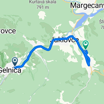
A cycling route starting in Gelnica, Košice Region, Slovakia.
Overview
About this route
We begin at Palenčáreň, down to GL, through the city to the main road and through Jaklovce to Margecany - asphalt to warm up :o) Under the bridges in Margecany we turn right (towards chalet Marica), over the dam through Rolova huta we enter the tunnel, about 450 meters in the dark. After the tunnel, a gravel road begins, a long climb alternating short descents and many beautiful curves. At the end of the climb, a steep forest asphalt begins, dropping sharply to the dam wall of the Ružín dam. Above the water, we continue towards Malá lodina. Before the bridge (which is on the right) we turn left steeply uphill and pass by the cabins, the Bujanovský tunnel and a little higher also by the ventilation shaft, all on a new asphalt road in the forest. From the asphalt road, we turn right onto a forest road and steeply ascend to the intersection, turn left and after a while we emerge onto the meadows. We turn left and continue through the forest along the ridge with a nice descent. Above Margecany we emerge onto the asphalt and steeply descend into the village, passing under the bridges and briefly returning in the
- -:--
- Duration
- 63.4 km
- Distance
- 1,425 m
- Ascent
- 1,425 m
- Descent
- ---
- Avg. speed
- ---
- Max. altitude
Route quality
Waytypes & surfaces along the route
Waytypes
Track
45.6 km
(72 %)
Road
3.2 km
(5 %)
Surfaces
Paved
19.6 km
(31 %)
Unpaved
34.2 km
(54 %)
Unpaved (undefined)
19 km
(30 %)
Asphalt
15.2 km
(24 %)
Route highlights
Points of interest along the route
Point of interest after 61.5 km
Rovno dole na cechy, alebo doprava hore na krásny singel? Určite doprava!!!
Continue with Bikemap
Use, edit, or download this cycling route
You would like to ride Palenčáreň 2015 "dlhá" or customize it for your own trip? Here is what you can do with this Bikemap route:
Free features
- Save this route as favorite or in collections
- Copy & plan your own version of this route
- Sync your route with Garmin or Wahoo
Premium features
Free trial for 3 days, or one-time payment. More about Bikemap Premium.
- Navigate this route on iOS & Android
- Export a GPX / KML file of this route
- Create your custom printout (try it for free)
- Download this route for offline navigation
Discover more Premium features.
Get Bikemap PremiumFrom our community
Other popular routes starting in Gelnica
 Mníšek nad Hnilcom-Úhorná-Úhornianske sedlo-sedlo medzi Bielimi Skalami a Hekerovou- Stará Voda- Mníšek nad Hnilcom
- Distance
- 47.8 km
- Ascent
- 982 m
- Descent
- 974 m
- Location
- Gelnica, Košice Region, Slovakia
 Palenčáreň 2015 "krátka"
- Distance
- 31.9 km
- Ascent
- 787 m
- Descent
- 787 m
- Location
- Gelnica, Košice Region, Slovakia
 Okolo Ružína
- Distance
- 44.7 km
- Ascent
- 948 m
- Descent
- 953 m
- Location
- Gelnica, Košice Region, Slovakia
 Gelnica - chata Diana - Tatarkov kríž
- Distance
- 8 km
- Ascent
- 670 m
- Descent
- 158 m
- Location
- Gelnica, Košice Region, Slovakia
 Gelnica- Jaklovce- V. Folkmar- v.n. Jaklovce
- Distance
- 8.9 km
- Ascent
- 117 m
- Descent
- 106 m
- Location
- Gelnica, Košice Region, Slovakia
 Tatarkov kríž-Gáborka-Slovenské cechy-Thurzov jazero
- Distance
- 5.2 km
- Ascent
- 97 m
- Descent
- 460 m
- Location
- Gelnica, Košice Region, Slovakia
 jaklovce_kurtovaskala_plejsy_thurzov_jaklovce
- Distance
- 27.6 km
- Ascent
- 676 m
- Descent
- 676 m
- Location
- Gelnica, Košice Region, Slovakia
 Palenčáreň 2015 "dlhá"
- Distance
- 63.4 km
- Ascent
- 1,425 m
- Descent
- 1,425 m
- Location
- Gelnica, Košice Region, Slovakia
Open it in the app