

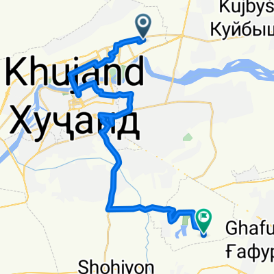
Przełęcz Anzob i Shahristan
A cycling route starting in Khujand, Viloyati Sughd, Tajikistan.
Overview
About this route
300 kilometrowy odcinek z Chodżentu do Duszanbe, przez dwie przełęcze - ANzob i Shahristan.
- -:--
- Duration
- 311 km
- Distance
- 4,666 m
- Ascent
- 4,182 m
- Descent
- ---
- Avg. speed
- ---
- Max. altitude
Continue with Bikemap
Use, edit, or download this cycling route
You would like to ride Przełęcz Anzob i Shahristan or customize it for your own trip? Here is what you can do with this Bikemap route:
Free features
- Save this route as favorite or in collections
- Copy & plan your own version of this route
- Split it into stages to create a multi-day tour
- Sync your route with Garmin or Wahoo
Premium features
Free trial for 3 days, or one-time payment. More about Bikemap Premium.
- Navigate this route on iOS & Android
- Export a GPX / KML file of this route
- Create your custom printout (try it for free)
- Download this route for offline navigation
Discover more Premium features.
Get Bikemap PremiumFrom our community
Other popular routes starting in Khujand
 От 19 микрорайон, Худжанд до улица Автобазовская, Худжанд
- Distance
- 6.7 km
- Ascent
- 77 m
- Descent
- 51 m
- Location
- Khujand, Viloyati Sughd, Tajikistan
 Przełęcz Anzob i Shahristan
- Distance
- 311 km
- Ascent
- 4,666 m
- Descent
- 4,182 m
- Location
- Khujand, Viloyati Sughd, Tajikistan
 khujand dushanbe
- Distance
- 303.8 km
- Ascent
- 5,132 m
- Descent
- 4,672 m
- Location
- Khujand, Viloyati Sughd, Tajikistan
 Chudshand - Kanibadam
- Distance
- 80.2 km
- Ascent
- 282 m
- Descent
- 202 m
- Location
- Khujand, Viloyati Sughd, Tajikistan
 Чкаловск
- Distance
- 25.1 km
- Ascent
- 212 m
- Descent
- 133 m
- Location
- Khujand, Viloyati Sughd, Tajikistan
 ТАДЖИКИСТАН-2013
- Distance
- 891.1 km
- Ascent
- 11,363 m
- Descent
- 11,362 m
- Location
- Khujand, Viloyati Sughd, Tajikistan
 Уверенная езда
- Distance
- 16.6 km
- Ascent
- 336 m
- Descent
- 318 m
- Location
- Khujand, Viloyati Sughd, Tajikistan
 Худжанд-Душанбе
- Distance
- 306.1 km
- Ascent
- 7,930 m
- Descent
- 7,416 m
- Location
- Khujand, Viloyati Sughd, Tajikistan
Open it in the app