

3ª Etapa CCCS 12/04/2015
A cycling route starting in Écija, Andalusia, Spain.
Overview
About this route
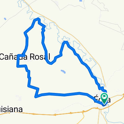
<span style="font-family: "Helvetica Neue",Arial,Helvetica,sans-serif;"><span style="background: transparent;">ECIJA-LA PALMOSA LARGA-MECANICO-CAMINO MOLINO DE LAS VALBUENAS-CERCA DEL TARANCON-(REAGRUP)-PINEDAS-CORTIJO GRANJA LA FLOR-CAÑADA-(AVITUALL)-CORTIJO VISTAHERMOSA-SENDA LORA- LA HERMITA-ALGARROBO-CAMINO CAMPILLO-ECIJA</span></span>
- -:--
- Duration
- 52.3 km
- Distance
- 276 m
- Ascent
- 276 m
- Descent
- ---
- Avg. speed
- ---
- Max. altitude
Route quality
Waytypes & surfaces along the route
Waytypes
Track
45.5 km
(87 %)
Road
3.7 km
(7 %)
Quiet road
3.1 km
(6 %)
Surfaces
Unpaved
12 km
(23 %)
Gravel
11.5 km
(22 %)
Unpaved (undefined)
0.5 km
(1 %)
Undefined
40.2 km
(77 %)
Route highlights
Points of interest along the route
Point of interest after 12.5 km
Inicio Cuesta de La Palmosa (larga)
Point of interest after 14.8 km
Inicio Cuesta del Mecánico
Point of interest after 23.8 km
Tarancón
Point of interest after 25.6 km
Pinedas
Point of interest after 29.1 km
Cortijo de La Flor
Point of interest after 29.3 km
Granja
Point of interest after 32.9 km
Cortijo Vistahermosa
Point of interest after 35 km
La Ermita
Point of interest after 39 km
Cortijo del Algarrobo
Continue with Bikemap
Use, edit, or download this cycling route
You would like to ride 3ª Etapa CCCS 12/04/2015 or customize it for your own trip? Here is what you can do with this Bikemap route:
Free features
- Save this route as favorite or in collections
- Copy & plan your own version of this route
- Sync your route with Garmin or Wahoo
Premium features
Free trial for 3 days, or one-time payment. More about Bikemap Premium.
- Navigate this route on iOS & Android
- Export a GPX / KML file of this route
- Create your custom printout (try it for free)
- Download this route for offline navigation
Discover more Premium features.
Get Bikemap PremiumFrom our community
Other popular routes starting in Écija
 2 CARRETERA CCCS2017
- Distance
- 85.9 km
- Ascent
- 439 m
- Descent
- 440 m
- Location
- Écija, Andalusia, Spain
 Ruta del lagarto 2016
- Distance
- 73.2 km
- Ascent
- 306 m
- Descent
- 306 m
- Location
- Écija, Andalusia, Spain
 1 COMBINADA BTT CCCS2017
- Distance
- 53.9 km
- Ascent
- 268 m
- Descent
- 276 m
- Location
- Écija, Andalusia, Spain
 1 CARRETERA COMBINADA CCCS2017
- Distance
- 65.2 km
- Ascent
- 427 m
- Descent
- 434 m
- Location
- Écija, Andalusia, Spain
 3ª Etapa CCCS 12/04/2015
- Distance
- 52.3 km
- Ascent
- 276 m
- Descent
- 276 m
- Location
- Écija, Andalusia, Spain
 CC 8 junio 2013
- Distance
- 38.6 km
- Ascent
- 163 m
- Descent
- 166 m
- Location
- Écija, Andalusia, Spain
 Etapa 7/6/2015 CCCS Écija
- Distance
- 65.3 km
- Ascent
- 415 m
- Descent
- 416 m
- Location
- Écija, Andalusia, Spain
 CX 26 MAR 2016
- Distance
- 61.8 km
- Ascent
- 307 m
- Descent
- 304 m
- Location
- Écija, Andalusia, Spain
Open it in the app