

Niers - Schloss Wickrath - Nordpark - Süchteln - Niers
A cycling route starting in Mönchengladbach, North Rhine-Westphalia, Germany.
Overview
About this route
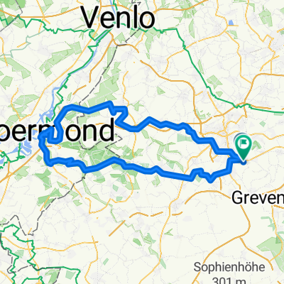
An der Niers bis nach Wickrathberg, dann zwischen Nordpark und Rheindalen/Hard nach Venn- Winkeln.
Von dort aus gehts über die Felder bei Viesen- Dülken zum Kletterwald Niederrhein. Dann noch ein wenig an Viersen entlang und man kommt wieder an die Niers. dieser folgt man bis zum Volksgarten und fährt dann zum Ausgangspunkt zurück. Trinkwasser sollte genügend mitgenommen werden! (cloned from route 1774526)- -:--
- Duration
- 66.9 km
- Distance
- 105 m
- Ascent
- 105 m
- Descent
- ---
- Avg. speed
- ---
- Max. altitude
Route quality
Waytypes & surfaces along the route
Waytypes
Track
30.1 km
(45 %)
Path
19.8 km
(30 %)
Surfaces
Paved
22.2 km
(33 %)
Unpaved
31.8 km
(47 %)
Asphalt
17.3 km
(26 %)
Gravel
16.7 km
(25 %)
Route highlights
Points of interest along the route
Point of interest after 13.1 km
Tankstelle
Point of interest after 44.9 km
Hier gibt es, wenn geöffnet, trinkwasser zu kaufen
Continue with Bikemap
Use, edit, or download this cycling route
You would like to ride Niers - Schloss Wickrath - Nordpark - Süchteln - Niers or customize it for your own trip? Here is what you can do with this Bikemap route:
Free features
- Save this route as favorite or in collections
- Copy & plan your own version of this route
- Sync your route with Garmin or Wahoo
Premium features
Free trial for 3 days, or one-time payment. More about Bikemap Premium.
- Navigate this route on iOS & Android
- Export a GPX / KML file of this route
- Create your custom printout (try it for free)
- Download this route for offline navigation
Discover more Premium features.
Get Bikemap PremiumFrom our community
Other popular routes starting in Mönchengladbach
 Abendrunde
- Distance
- 30.4 km
- Ascent
- 38 m
- Descent
- 36 m
- Location
- Mönchengladbach, North Rhine-Westphalia, Germany
 Zigarren holen in Holland
- Distance
- 106.1 km
- Ascent
- 204 m
- Descent
- 186 m
- Location
- Mönchengladbach, North Rhine-Westphalia, Germany
 Morgenrunde
- Distance
- 35 km
- Ascent
- 91 m
- Descent
- 94 m
- Location
- Mönchengladbach, North Rhine-Westphalia, Germany
 Feierabendrunde Mönchengladbach
- Distance
- 25.6 km
- Ascent
- 51 m
- Descent
- 55 m
- Location
- Mönchengladbach, North Rhine-Westphalia, Germany
 Ruckes40
- Distance
- 41.3 km
- Ascent
- 37 m
- Descent
- 43 m
- Location
- Mönchengladbach, North Rhine-Westphalia, Germany
 Grenzfahrer Sonntagsrunde (lang)
- Distance
- 103.3 km
- Ascent
- 297 m
- Descent
- 304 m
- Location
- Mönchengladbach, North Rhine-Westphalia, Germany
 Venn-Holtmühle-Tüschenbroich-Venn
- Distance
- 41.5 km
- Ascent
- 85 m
- Descent
- 83 m
- Location
- Mönchengladbach, North Rhine-Westphalia, Germany
 Von Rheydt zum Adolfosee bei Hückelhoven an der Rur
- Distance
- 58.6 km
- Ascent
- 118 m
- Descent
- 118 m
- Location
- Mönchengladbach, North Rhine-Westphalia, Germany
Open it in the app