

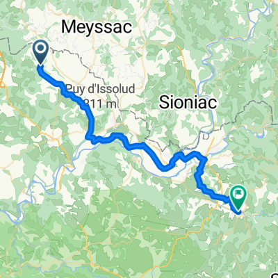
Collonges la Rouge - Rocamadour
A cycling route starting in Meyssac, Nouvelle-Aquitaine, France.
Overview
About this route
Collonges la Rouge - Rocamadour 34.3 km
- -:--
- Duration
- 34.3 km
- Distance
- 366 m
- Ascent
- 351 m
- Descent
- ---
- Avg. speed
- ---
- Max. altitude
Route quality
Waytypes & surfaces along the route
Waytypes
Road
15.4 km
(45 %)
Quiet road
9.3 km
(27 %)
Surfaces
Paved
22 km
(64 %)
Asphalt
22 km
(64 %)
Undefined
12.4 km
(36 %)
Continue with Bikemap
Use, edit, or download this cycling route
You would like to ride Collonges la Rouge - Rocamadour or customize it for your own trip? Here is what you can do with this Bikemap route:
Free features
- Save this route as favorite or in collections
- Copy & plan your own version of this route
- Sync your route with Garmin or Wahoo
Premium features
Free trial for 3 days, or one-time payment. More about Bikemap Premium.
- Navigate this route on iOS & Android
- Export a GPX / KML file of this route
- Create your custom printout (try it for free)
- Download this route for offline navigation
Discover more Premium features.
Get Bikemap PremiumFrom our community
Other popular routes starting in Meyssac
 devils chair
- Distance
- 13.6 km
- Ascent
- 547 m
- Descent
- 553 m
- Location
- Meyssac, Nouvelle-Aquitaine, France
 Trip vélo Cantal - Corrèze 2011 - 04 - Collonges la Rouge / Argentat
- Distance
- 49.7 km
- Ascent
- 438 m
- Descent
- 450 m
- Location
- Meyssac, Nouvelle-Aquitaine, France
 saint-cirq lapopie
- Distance
- 98.7 km
- Ascent
- 1,449 m
- Descent
- 1,311 m
- Location
- Meyssac, Nouvelle-Aquitaine, France
 2021 vakantie rit 4 - met Jolanda - Dordogne 2
- Distance
- 72.3 km
- Ascent
- 1,002 m
- Descent
- 1,002 m
- Location
- Meyssac, Nouvelle-Aquitaine, France
 02 Gaskoňsko 2011 - Collonges la Rouge
- Distance
- 46 km
- Ascent
- 655 m
- Descent
- 581 m
- Location
- Meyssac, Nouvelle-Aquitaine, France
 Impasse de la Romaine, Cressensac-Sarrazac à Place de la République, Saint-Céré
- Distance
- 44.1 km
- Ascent
- 399 m
- Descent
- 467 m
- Location
- Meyssac, Nouvelle-Aquitaine, France
 Rignac
- Distance
- 44.2 km
- Ascent
- 656 m
- Descent
- 656 m
- Location
- Meyssac, Nouvelle-Aquitaine, France
 Saint-julien-maumont dordogne martel
- Distance
- 44.2 km
- Ascent
- 647 m
- Descent
- 647 m
- Location
- Meyssac, Nouvelle-Aquitaine, France
Open it in the app