

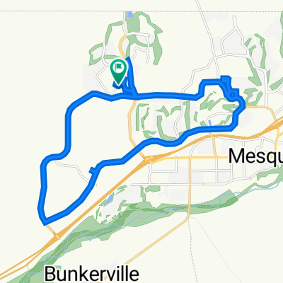
Sun City Bike Club Easy Ride 1 Out and Back Around Mesquite and Bunkerville
A cycling route starting in Mesquite, Nevada, United States.
Overview
About this route
This is a fairly flat and easy out and back ride from Sun City Mesquite. The ride starts with a mostly downhill ride to Sunset Greens; a slight uphill ride to Riverside Road (NV 170); a slight up and down ride to and through Bunkerville and back to Hafen Lane; a relatively flat ride back through the two roundabouts and passed West Pioneer Boulevard; then a pretty good climb to the finish. Total Ride Distance: 19.4 Miles.
Notes: 1. If you open the route in Google Roadmap or Google Hybrid (pulled down from the "Relief Map" tab) you will get a more up-to-date view of the roads and paths. Some of the other maps are dated. 2. Riverside Road can be ridden either on a pedestrian/bike path (shown on the map) or on the roadway itself. There is some traffic, particularly heading from Bunkerville back into Mesquite. 3. Part of the ride within the city of Mesquite is also on a separate pedestrian/bike path (shown on the map) starting off of Hafen Lane and ending at Old Mill Road. 4. This mapping program tends to under-compute the total ride mileage by roughly 10%, based on mileage for this ride when it has been actually ridden. - -:--
- Duration
- 31.3 km
- Distance
- 116 m
- Ascent
- 117 m
- Descent
- ---
- Avg. speed
- ---
- Max. altitude
Route quality
Waytypes & surfaces along the route
Waytypes
Cycleway
9.4 km
(30 %)
Quiet road
6.9 km
(22 %)
Surfaces
Paved
22.8 km
(73 %)
Asphalt
17.8 km
(57 %)
Concrete
4.4 km
(14 %)
Continue with Bikemap
Use, edit, or download this cycling route
You would like to ride Sun City Bike Club Easy Ride 1 Out and Back Around Mesquite and Bunkerville or customize it for your own trip? Here is what you can do with this Bikemap route:
Free features
- Save this route as favorite or in collections
- Copy & plan your own version of this route
- Sync your route with Garmin or Wahoo
Premium features
Free trial for 3 days, or one-time payment. More about Bikemap Premium.
- Navigate this route on iOS & Android
- Export a GPX / KML file of this route
- Create your custom printout (try it for free)
- Download this route for offline navigation
Discover more Premium features.
Get Bikemap PremiumFrom our community
Other popular routes starting in Mesquite
 870 Deep Gorge Trail, Mesquite to 1350 Flat Top Mesa Dr, Mesquite
- Distance
- 27.3 km
- Ascent
- 281 m
- Descent
- 243 m
- Location
- Mesquite, Nevada, United States
 Mesquite, NV - Mount Charleston, NV
- Distance
- 182.8 km
- Ascent
- 2,261 m
- Descent
- 464 m
- Location
- Mesquite, Nevada, United States
 1350 Flat Top Mesa Dr, Mesquite to 1173 Clouds Rest Pt, Mesquite
- Distance
- 0.9 km
- Ascent
- 21 m
- Descent
- 32 m
- Location
- Mesquite, Nevada, United States
 Cycle-a-thon for Cancer
- Distance
- 16.3 km
- Ascent
- 132 m
- Descent
- 162 m
- Location
- Mesquite, Nevada, United States
 Settlers Way, Mesquite to 870 Deep Gorge Trail, Mesquite
- Distance
- 23.8 km
- Ascent
- 331 m
- Descent
- 324 m
- Location
- Mesquite, Nevada, United States
 Sun City Bike Club Easy Ride 2 Out and Back Around Mesquite (With Some Climbs)
- Distance
- 20.1 km
- Ascent
- 213 m
- Descent
- 215 m
- Location
- Mesquite, Nevada, United States
 Settlers Way, Mesquite to 1350 Flat Top Mesa Dr, Mesquite
- Distance
- 15.1 km
- Ascent
- 232 m
- Descent
- 194 m
- Location
- Mesquite, Nevada, United States
 Route to St. George
- Distance
- 79.3 km
- Ascent
- 1,232 m
- Descent
- 893 m
- Location
- Mesquite, Nevada, United States
Open it in the app