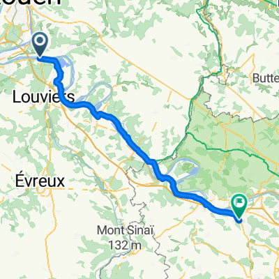
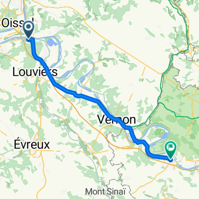
sortie
A cycling route starting in Igoville, Normandy, France.
Overview
About this route
entren
- -:--
- Duration
- 56.5 km
- Distance
- 359 m
- Ascent
- 359 m
- Descent
- ---
- Avg. speed
- ---
- Max. altitude
Route quality
Waytypes & surfaces along the route
Waytypes
Road
15.8 km
(28 %)
Quiet road
6.2 km
(11 %)
Surfaces
Paved
22.6 km
(40 %)
Asphalt
22.6 km
(40 %)
Undefined
33.9 km
(60 %)
Continue with Bikemap
Use, edit, or download this cycling route
You would like to ride sortie or customize it for your own trip? Here is what you can do with this Bikemap route:
Free features
- Save this route as favorite or in collections
- Copy & plan your own version of this route
- Sync your route with Garmin or Wahoo
Premium features
Free trial for 3 days, or one-time payment. More about Bikemap Premium.
- Navigate this route on iOS & Android
- Export a GPX / KML file of this route
- Create your custom printout (try it for free)
- Download this route for offline navigation
Discover more Premium features.
Get Bikemap PremiumFrom our community
Other popular routes starting in Igoville
- De Quai de Verdun 100, Pont-de-l'Arche à Quai de Verdun 100, Pont-de-l'Arche
- Distance
- 70.8 km
- Ascent
- 480 m
- Descent
- 481 m
- Location
- Igoville, Normandy, France
- Chemin du Becquet 4, Pont-de-l'Arche nach Rue du Gén de Gaulle, La Bonneville-sur-Iton
- Distance
- 1.3 km
- Ascent
- 4 m
- Descent
- 55 m
- Location
- Igoville, Normandy, France
- Tour d´Alizay
- Distance
- 84.1 km
- Ascent
- 753 m
- Descent
- 740 m
- Location
- Igoville, Normandy, France
- SEI1_Pont de l'Arche
- Distance
- 37.2 km
- Ascent
- 73 m
- Descent
- 73 m
- Location
- Igoville, Normandy, France
- De Quai Maréchal Foch 7, Pont-de-l'Arche à Quai Maréchal Foch 41, Pont-de-l'Arche
- Distance
- 21 km
- Ascent
- 67 m
- Descent
- 69 m
- Location
- Igoville, Normandy, France
- 16 Mars 2014
- Distance
- 58.1 km
- Ascent
- 360 m
- Descent
- 360 m
- Location
- Igoville, Normandy, France
- Dimanche 26 août 2018 circuit Pont de l'Arche
- Distance
- 37.1 km
- Ascent
- 64 m
- Descent
- 66 m
- Location
- Igoville, Normandy, France
- De Quai Maréchal Foch 41, Pont-de-l'Arche à D110, Lery
- Distance
- 19.9 km
- Ascent
- 82 m
- Descent
- 91 m
- Location
- Igoville, Normandy, France
Open it in the app